An area of low pressure will bring periods of showers to the region tonight through tomorrow afternoon, but the whole weekend will not be a washout.
An area of low pressure will approach the region from the west with increasing clouds throughout the day. Showers will develop in the afternoon over eastern Pennsylvania. Winds will veer to the southeast at 5 to 15 mph. Temperatures will rise into the upper 50s to lower 60s over the interior, lower to mid-60s along the coast, and mid to upper 60s in the Delaware River Valley for highs.
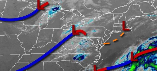
An area of low pressure and trough will pass through the region tonight through tomorrow afternoon with periods of showers, heavy at times. The heaviest rainfall is expected to be in northeastern Pennsylvania and northwestern New Jersey with an inch of rain possible. Skies will clear in the late afternoon and evening hours. Winds will back to the west at 5 to 15 mph. Temperatures range from the lower to mid-40s over the interior and
mid to upper 40s along the coast for lows and lower to mid-50s over the interior and upper 50s to lower 60s along the coast for highs.
High pressure will briefly build into the region tomorrow night through Sunday morning with clear skies to scattered cloud cover. Winds will be from the northwest at 5 to 15 mph. Temperatures will fall into the mid-30s to lower 40s for lows.
An area of low pressure will approach on Sunday afternoon with increasing clouds and rain developing in the evening. Winds will back to the southwest at 5 to 15 mph. Temperatures will rise into the mid-50s to lower 60s for highs.
An area of low pressure will pass through the region Sunday night through Monday morning with periods of rain, heavy at times. Skies will clear on Monday afternoon. Temperatures will range from the lower to mid-40s over the interior and upper 40s to lower 50s along the coast for lows and lower to mid-50s over the interior and upper 50s to mid-60s along the coast for highs.
High pressure will be in control Tuesday and Wednesday with clear skies to scattered cloud cover. Temperatures will range from the lower to mid-30s over the interior and upper 30s to mid-40s along the coast for lows and lower to mid-50s over the interior and upper 50s to lower 60s along the coast for highs.
An area of low pressure will approach on Thursday with increasing clouds and rain towards evening. Widespread rainfall, heavy at times, is expected throughout the day on Friday. Temperatures on Thursday will range from the mid to upper 30s over the interior and lower to mid-40s along the coast for lows and mid to upper 50s over the interior and upper 50s to lower 60s along the coast for highs. Temperatures on Friday will range from the
lower to mid-40s over the interior and upper 40s to lower 50s along the coast for lows and lower to mid-50s over the interior and mid to upper 50s along the coast for highs.