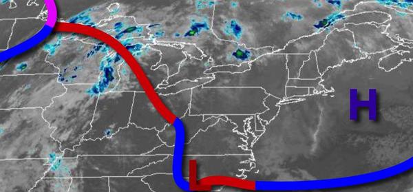
An advancing warm front will bring warmer conditions by this afternoon. Hot and humid conditions return tomorrow with a threat for thunderstorms followed by a west start to the Memorial Day Weekend.
High pressure will exit today while a warm front approaches this evening with scattered to broken clouds and isolated showers. Winds will be from the south at 5 to 15 mph. Temperatures will rise into the mid-60s to lower 70s along the coast and mid to upper 70s away from the coast for highs.
The warm front will lift north of the region tonight with broken to overcast clouds, isolated showers, drizzle, and locally dense fog. Winds will veer from the south to southwest at 5 to 10 mph. Temperatures will fall into the lower to mid-60s for lows.
A cold front will move through the region tomorrow afternoon and evening with scattered showers and strong to severe thunderstorms. The thunderstorms will be capable of heavy downpours, frequent lightning, small hail, and wind gusts over 40 mph. Winds will veer from the southwest to the northwest at 5 to 15 mph. Temperatures will rise into the mid-70s to lower 80s along the coast, mid to upper 80s over the interior, and mid-80s to lower
90s in the Delaware River Valley for highs with humid conditions.
The cold front will clear the region on Thursday with a few isolated showers in the morning followed by clearing skies in the afternoon and evening. Humidity will be much lower. Winds will be from the northwest at 5 to 15 mph. Temperatures will range from the lower to mid-60s over the interior and mid-60s to lower 70s along the coast for lows and mid-70s to lower 80s over the interior, lower to mid-80s along the coast, and mid-80s to
lower 90s in the Delaware River Valley for highs.
An area of low pressure will move through the region on Friday with periods of rain, heavy at times, expected throughout the day. Temperatures will range from the upper 40s to mid-50s over the interior and mid-50s to lower 60s along the coast for lows and mid-50s to lower 60s over the interior, mid-60s to lower 70s along the coast, and upper 60s to mid-70s in the Delaware River Valley for highs.
A few showers will linger in the morning on Saturday followed by clearing skies in the afternoon and evening. Temperatures will range from the lower to mid-40s over the interior and upper 40s to lower 50s along the coast for lows and mid-50s to lower 60s for highs.
High pressure will be in complete control on Sunday and Memorial Day Monday with clear skies to scattered cloud cover. Temperatures on Sunday will range from the upper 30s to mid-40s over the interior and upper 40s to lower 50s along the coast for lows and lower to mid-60s over the interior and immediate coast and mid to upper 60s in the Delaware River Valley for highs. Temperatures on Monday will range from the lower to mid-40s for lows and
mid to upper 60s over the interior, upper 60s to lower 70s along the coast, and lower to mid-70s in the Delaware River Valley for highs.
Another area of low pressure will produce periods of showers on Tuesday. Temperatures will range from the lower to mid-50s for lows and lower to mid-60s along the coast and mid-60s to lower 70s away from the coast for highs.