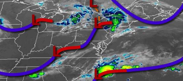
A series of cold fronts will bring the threat for showers and strong to severe thunderstorms through tomorrow morning. A drier weather pattern returns for the rest of the week.
A cold front will approach today with scattered to broken clouds and scattered showers and thunderstorms. Winds will be from the south at 5 to 15 mph. Temperatures will rise into the upper 60s to mid-70s along the coast and mid-70s to lower 80s away from the coast for highs.
The cold front will move through the region tonight with scattered showers and strong to severe thunderstorms. The thunderstorms will be capable of heavy downpours, frequent lightning, hail, and wind gusts over 40 mph with wind damage, flash flooding, and power outages a threat. Winds will veer to the northwest at 5 to 15 mph. Temperatures will fall into the mid-50s to lower 60s over the interior and lower to mid-60s along the coast for
lows.
Another cold front will pass through the region tomorrow with scattered showers through the afternoon followed by clearing skies. Winds will be from the northwest at 5 to 15 mph. Temperatures will rise into the lower to mid-70s over the interior and mid-70s to lower 80s along the coast for highs.
High pressure will build into the region on Wednesday with clear skies to scattered cloud cover. Winds will be from the northwest at 5 to 15 mph. Temperatures on Wednesday will range from the lower to mid-50s over the interior and upper 50s to lower 60s along the coast for lows and upper 60s to lower 70s over the interior and mid-70s to lower 80s along the coast for highs.
High pressure will remain in control Thursday and Friday with clear skies to scattered cloud cover. Temperatures on Thursday will range from the mid-40s to lower 50s over the interior and mid to upper 50s along the coast for lows and lower to mid-70s over the interior and mid to upper 70s along the coast for highs. Temperatures on Friday will range from the lower to mid-50s for lows and upper 70s to lower 80s for highs.
A series of low-pressure systems will pass through the region Saturday through Monday with scattered to broken clouds and isolated to widely scattered showers. Temperatures on Saturday will range from the lower to mid-60s over the interior and mid to upper 60s along the coast for lows and mid-70s to lower 80s along the coast, lower to mid-80s over the interior, and mid to upper 80s in the Delaware River Valley for highs. Temperatures on Sunday
will range from the upper 50s to lower 60s over the interior and mid to upper 60s along the coast for lows and upper 70s to lower 80s over the interior, lower to mid-80s along the coast, and mid to upper 80s in the Delaware River Valley for highs. Temperatures on Monday will range from the upper 50s to lower 60s over the interior and mid to upper 60s along the coast for lows and mid-70s to lower 80s along the coast, upper 70s to mid-80s over the interior, and mid to upper 80s in the
Delaware River Valley for highs.