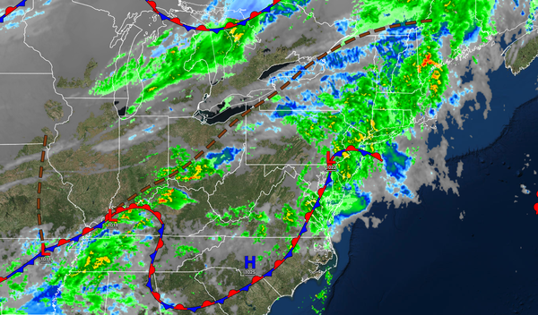
A cold front will continue to sink through the region through tomorrow. An active weather pattern continues into the weekend.
TONIGHT
Periods of rain will move through the region. Winds will be
from the southwest at 5 to 15 mph. Temperatures will fall into the mid to upper 40s over the interior and lower to mid-50s along the coast for lows.
TOMORROW
A cold front will slowly move through the region and produce scattered showers. Winds will veer to the west at 5 to 15 mph. Temperatures will rise into the lower to mid-50s over the interior and
mid-50s to lower 60s along the coast for highs.
TOMORROW NIGHT
Skies will clear as high pressure build into the region. Winds will be from the west at 5 to 15 mph. Temperatures will fall into the lower to mid-40s over the interior and upper 40s to lower 50s along the coast for lows.
THURSDAY
High pressure will produce clear skies to scattered clouds. Winds will veer to the northwest at 5 to 15 mph. Temperatures will rise into the lower to mid-40s over the interior and upper 40s to lower 50s along the coast for highs.
FRIDAY
An area of low
pressure will approach the region with increasing clouds followed by a wintry mix of widely scattered snow, sleet, and rain showers in the afternoon and evening. Winds will be from the north at 5 to 15 mph. Temperatures will range from the lower to mid-30s over the interior and upper 30s to lower 40s along the coast for lows and lower to mid-40s for highs.
SATURDAY
An area of low pressure will exit with a wintry mix of widely scattered snow, sleet, and rain showers in the morning giving way to clearing skies in the afternoon and evening. Winds will be from the northeast at 5 to 15 mph. Temperatures will range from the lower to mid-20s over the interior and upper 20s to lower 30s along the coast for lows and upper 30s to lower 40s over the interior and lower to mid-40s along the coast for
highs.
SUNDAY
A trough will linger over the region with scattered clouds and isolated rain and snow showers. Temperatures will range from the lower to mid-20s over the interior and mid to upper 20s along the coast for lows and upper 30s to lower 40s for highs.
MONDAY
A trough will linger over the region with scattered clouds and isolated rain and snow showers. Temperatures will range from the mid to upper 30s for lows and upper 30s to lower 40s for highs.
TUESDAY
High pressure will produce scattered clouds and dry
conditions. Temperatures will range from the lower to mid-30s over the interior and upper 30s to lower 40s along the coast for lows and upper 30s to lower 40s over the interior and lower to mid-40s along the coast for highs.
WEDNESDAY
High pressure will exit the region with increasing clouds. Temperatures will range from the lower to mid-20s over the interior
and upper 20s to lower 30s along the coast for lows and upper 30s to lower 40s over the interior and mid to upper 40s along the coast for highs.