The weather pattern is towards a colder and more active theme with the first minor threat this weekend. Additional threats are starting to show up as well.
TODAY
A weak trough will pass through the
region with scattered clouds and isolated rain and snow showers. Winds will be from the north at 5 to 15 mph. Temperatures will rise into the lower to mid-40s for highs.
TONIGHT
Cloudy skies with a few isolated rain and snow showers will be possible. Winds will be from the northeast at 5 to 15 mph. Temperatures will fall into the mid to
upper 20s over the interior and upper 20s to lower 30s along the coast for lows.
TOMORROW
An area of low pressure will exit the region with a few isolated rain and snow showers in the morning followed by scattered clouds in the afternoon and evening. Winds will be from the north at 5 to 15 mph. Temperatures will rise into the upper 30s to lower 40s for
highs.
TOMORROW NIGHT
Scattered clouds are expected. Winds will be from the northeast at 5 to 15 mph. Temperatures will fall into the lower to mid-30s over the interior and mid to upper 30s along the coast for lows.
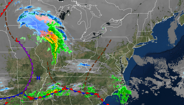
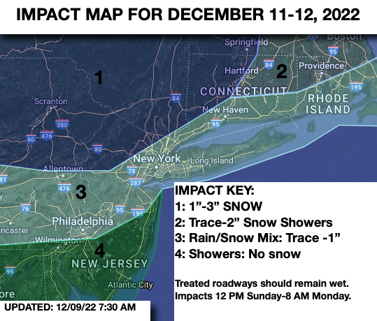
SUNDAY
Clouds will
increase with snow developing in the Poconos, Catskills, Hudson River Valley, and Hudson High Lands in the afternoon and evening. Rain will develop along the coast. Light snowfall accumulation can be expected. Winds will be from the east at 5 to 15 mph. Temperatures will rise into the mid to upper 30s over the interior and lower to mid-40s along the coast for highs.
MONDAY
Periods of light snow over the interior and a wintry mix along the coast can be expected in the morning followed by clearing skies in the afternoon and evening. Winds will back to the north at 5 to 15 mph. Temperatures will range from the lower to mid-30s for lows and mid to upper 30s for highs.