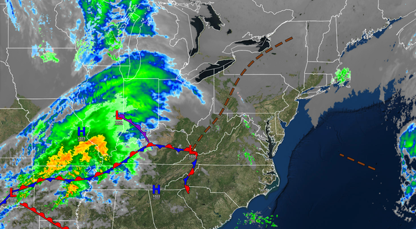
The active winter weather pattern has returned and with it the threat of snow, ice, rain, and much colder temperatures.
TODAY
A weak trough will produce scattered clouds and an isolated flurry. Winds will
be from the northeast at 5 to 15 mph. Temperatures will rise into the upper 30s to lower 40s for highs.
TONIGHT
Scattered clouds are expected with an isolated flurry possible. Winds will from the northeast at 5 to 15 mph. Temperatures will fall into the lower to mid-30s over the interior and mid to upper 30s along the coast for
lows.
TOMORROW
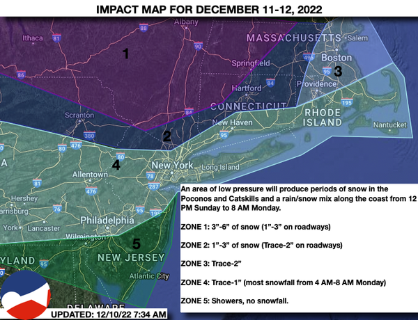
A redeveloping area of low pressure will approach the region with increasing clouds in the morning. Showers will develop in the afternoon for much of the region, but snow will develop in the Poconos, Catskills, the Hudson Highlands, and the Hudson River Valley. Winds will be from the east at 5 to 15 mph. Temperatures will rise into the
lower to mid-30s over the interior and upper 30s to mid-40s along the coast for highs.
TOMORROW NIGHT
Periods of snow will continue throughout northeastern Pennsylvania, the Catskills, the Hudson River Valley, northwestern New Jersey, and Connecticut. Meanwhile, the rain along the coast will begin to mix with sleet and snow at times. Winds will back to the
northeast at 5 to 15 mph. Temperatures will fall into the upper 20s to lower 30s over the interior and lower to mid-30s along the coast for lows.
MONDAY
The snow over the interior and wintry mix along the coast will exit the region in the morning followed by clearing skies by noon. Scattered clouds are expected in the afternoon. Winds will back from the
northeast to the northwest at 5 to 15 mph. Temperatures will rise into the mid to upper 30s over the interior and upper 30s to lower 40s along the coast for highs.