TOMORROW NIGHT
High pressure will build into the region with clearing skies. Winds will be from the northwest at 5 to 15 mph. Temperatures will fall into the single digits to mid-10s over the interior and upper 10s to mid-20s along the coast for lows.
TUESDAY
High pressure will produce scattered clouds. Winds will be from the northwest at 5 to 15 mph. Temperatures will rise into the lower to mid-30s over the interior and upper 30s to lower 40s along the coast for highs.
WEDNESDAY
High pressure will exit the
region with increasing clouds. Winds will be from the northwest at 5 to 15 mph. Temperatures will range from the mid to upper 10s over the interior and lower to mid-20s along the coast for lows and upper 20s to lower 30s over the interior and mid to upper 30s along the coast for highs.
THURSDAY
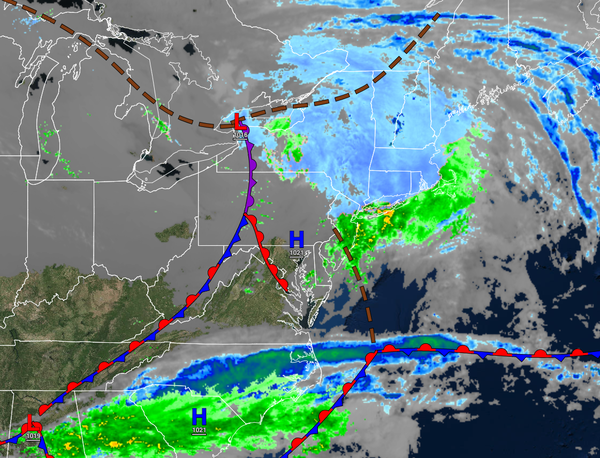
An area of low pressure will approach the region with a warm
front producing increasing clouds through the afternoon. Rain will develop in the evening along the coast while a mix of snow, sleet, and rain will develop over the interior. Winds will veer to the northeast at 5 to 15 mph. Temperatures will range from the lower to mid-10s over the interior, upper 10s to mid-20s in the suburbs, and upper 20s to lower 30s in urban areas for lows and lower to mid-30s over the interior and upper 30s to mid-40s along the coast for
highs.
FRIDAY
A new low-pressure system will develop along the coast with periods of snow, sleet, and rain over the interior and rain along the coast. Temperatures will hold in the mid to upper 30s over the interior and lower 40s to lower 50s along the coast for highs and then fall through the 40s, 30s, and 20s in the evening.
SATURDAY
The low-pressure system will exit with all rain changing over to snow showers before ending. The skies will clear in the afternoon and evening. Temperatures will range from the mid to upper 20s over the interior and lower to mid-30s along the coast for lows and lower to mid-30s over the interior and upper 30s to lower 40s along the coast for
highs.
SUNDAY
High pressure will produce clear skies to scattered clouds. Temperatures will range from the upper 10s to the lower 20s over the interior and mid to upper 20s along the coast for lows and upper 20s to lower 30s over the interior and mid to upper 30s along the coast for highs.
MONDAY
High pressure will produce clear skies to scattered clouds. Temperatures will range from the upper 10s to the lower 20s over the interior and lower to mid-20s along the coast for lows and lower to mid-30s over the interior and mid to upper 30s along the coast for highs.