Excellent weather will continue today, but a tropical air mass from the Gulf of Mexico will return by this weekend with more seasonal conditions expected.
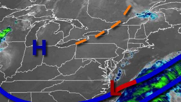
High pressure will pass over the region today with clear skies to scattered clouds. Winds will back from the northwest to the west at 5 to 15 mph. Temperatures will rise into the lower to mid-70s over the interior and mid to upper 70s along the coast for highs.
High pressure will exit off the coast tonight through tomorrow with scattered clouds expected. Winds will back from the west to the southwest at 5 to 15 mph. Temperatures will range from the mid to upper 50s for lows and mid-70s to lower 80s for most of the region, lower to mid-80s in the Delaware River Valley for highs.
A cold front will approach tomorrow night through Saturday with increasing clouds and isolated to widely scattered showers and thunderstorms. The thunderstorms will be capable of brief heavy downpours, frequent lightning, and wind gusts over 40 mph. Winds will be from the southwest at 5 to 15 mph. Temperatures will range from the lower to mid-60s over the interior and mid-60s to lower 70s along the coast for lows and lower to mid-80s over
the interior and mid-80s to lower 90s along the coast for highs.
The cold front will stall over the region on Sunday and Monday with areas of fog in the morning and scattered clouds with isolated thunderstorms in the afternoon and evening. Temperatures on Sunday will range from the mid-60s to lower 70s for lows and lower to mid-80s along the coast and mid-80s to lower 90s away from the coast for highs. Temperatures on Monday will range from the upper 60s to mid-70s for lows and lower to mid-80s along the
coast and mid-80s to lower 90s away from the coast for highs.
A powerful cold front and the remnants of a tropical low-pressure system from the Gulf of Mexico will produce periods of showers and thunderstorms capable of heavy downpours and frequent lightning on Tuesday. Temperatures will range from the lower to mid-70s for lows and upper 70s to mid-80s along the coast and mid-80s to lower 90s away from the coast for highs.
Canadian high pressure will be in control on Wednesday and Thursday with clear skies to scattered cloud cover. Temperatures on Wednesday will range from the upper 40s to mid-50s over the interior and upper 50s to mid-60s along the coast for lows and mid-60s to lower 70s over the interior and mid to upper 70s along the coast for highs. Temperatures on Thursday will range from the mid-40s to lower 50s over the interior and mid to upper 50s along
the coast for lows and upper 60s to mid-70s along the coast, mid to upper 70s in the Delaware River Valley, and lower to mid-70s over the interior for highs.