After several pleasant dry days, a tropical air mass will be returning just in time for the weekend with the threat of thunderstorms. However, this tropical weather pattern won't last long.
High pressure will continue to move to the east of the region with clear skies to scattered cloud cover. Winds will be from the southwest at 5 to 15 mph. Temperatures will rise into the mid to upper 70s along the coast and upper 70s to mid-80s away from the coast.
A cold front will approach the region tonight with increasing clouds and isolated showers and thunderstorms. The thunderstorms will be capable of brief heavy downpours and occasional lightning. Some fog may develop in a few locations reducing visibility below 3 miles. Winds will be from the southwest at 5 to 10 mph. Temperatures will fall into the lower to mid-60s over the interior and mid-60s to lower 70s along the coast for
lows.
The cold front will slowly move into and then stall over the region tomorrow through Sunday with scattered to broken cloud cover and isolated to widely scattered showers and thunderstorms. The highest threat for thunderstorms will be late tomorrow afternoon through early Sunday morning. The thunderstorms will be capable of torrential downpours, frequent vivid lightning, wind gusts over 40 mph, and small hail. Winds will be from the
southwest at 5 to 15 mph. Temperatures tomorrow will rise into the lower to mid-80s along the coast and higher elevations and mid-80s to lower 90s elsewhere for highs. Temperatures on Sunday will range from the lower to mid-60s for lows and lower to mid-80s along the coast and higher elevations and mid-80s to lower 90s elsewhere for highs.
The cold front will remain stalled over the region on Monday with areas of fog in the morning and scattered to broken clouds with isolated thunderstorms in the afternoon. Temperatures will range from the upper 60s to mid-70s for lows and upper 70s to mid-80s along the coast and upper 80s to lower 90s away from the coast for highs.
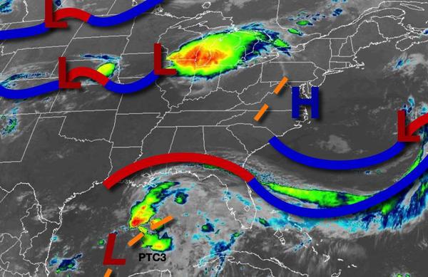
A more powerful cold front will drive through the region on Tuesday while the remnant moisture of PTC3 also lifts through the coastal waters which will produce widespread showers and thunderstorms capable of heavy downpours in the late morning through evening hours. Temperatures will range from the upper 60s to mid-70s for lows and upper 70s to mid-80s over the interior and along the coast and mid-80s to lower 90s in the Delaware River Valley for
highs.
High pressure will build into the region with clear skies to scattered cloud cover and much lower humidity for Wednesday through Friday. Temperatures on Wednesday will range from the lower to mid-50s over the interior and upper 50s to mid-60s along the coast for lows and upper 60s to mid-70s over the interior and mid-70s to lower 80s along the coast for highs. Temperatures on Thursday will range from the upper 40s to mid-50s over the interior
and upper 50s to lower 60s along the coast for lows and mid-70s to lower 80s along the coast and upper 70s to mid-80s away from the coast for highs. Temperatures on Friday will range from the mid-50s to lower 60s for lows and mid-70s to lower 80s along the coast and lower to mid-80s away from the coast for highs.