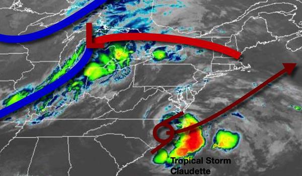
A tropical air mass will remain over the region today as Tropical Storm Claudette passes well to the east. A powerful cold front brings the end to the humid weather pattern with showers and thunderstorms tomorrow.
A weak trough will approach the region today with scattered to broken clouds and isolated thunderstorms in the afternoon. Winds will be from the southwest at 5 to 15 mph. Temperatures will rise into the mid-70s to lower 80s on Long Island, lower to mid-80s on the coast, and mid-80s to lower 90s in the Delaware River Valley and higher elevations.
A cold front will approach tonight with widely scattered showers and thunderstorms a threat. Winds will be from the southwest at 5 to 15 mph. Temperatures will fall into the mid-50s to lower 60s over the interior and mid-60s to lower 70s along the coast for lows.
The cold front will move through the region tomorrow with showers and thunderstorms in the afternoon hours. The thunderstorms will be capable of heavy downpours, lightning, and wind gusts over 40 mph at times. Winds will veer from the southwest to the northwest at 5 to 15 mph. Temperatures will rise into the lower to mid-60s for higher elevations, upper 60s to mid-70s for the rest of the interior, and upper 70s to lower 80s along the
coast for highs.
High pressure will pass through the region with clear skies to scattered cloud cover Tuesday evening through Wednesday. Winds will be light and variable. Temperatures will range from the upper 40s to lower 50s over the interior and mid to upper 50s along the coast for lows and upper 60s to lower 70s over the interior and mid to upper 70s along the coast for highs.
High pressure will linger off the coast Thursday and Friday with clear skies to scattered cloud cover. Temperatures on Thursday will range from the mid-50s for lows and mid-70s to lower 80s for highs. Temperatures on Friday will range from the mid-50s to lower 60s for lows and mid-70s to lower 80s for highs.
A series of cold fronts will approach but stall out over the region Saturday through Monday with fog and low clouds a threat in the morning and scattered clouds with isolated thunderstorms in the afternoon. Temperatures on Saturday will range from the mid-60s to lower 70s for lows and mid-70s to lower 80s along the coast, lower to mid-80s over the interior, and mid-80s to lower 90s in the Delaware River Valley for highs. Temperatures on Sunday
will range from the upper 60s to mid-70s for lows and upper 70s to lower 80s along the coast, lower to mid-80s over the interior, and mid-80s to lower 90s in the Delaware River Valley for highs. Temperatures on Monday will range from the lower to mid-70s for lows and upper 70s to lower 80s along the coast, lower to mid-80s for the higher elevations, and mid-80s to lower 90s in the Delaware River Valley for highs.