Excellent weather today gives way to a few pesky showers along the coast by tomorrow morning. A tropical air mass returns this weekend and lingers on through next week.
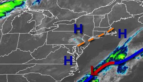
High pressure will move over the region today with clear skies to scattered cloud cover. Winds will be from the east at 5 to 15 mph. Temperatures will rise into the lower to mid-70s along the coast and mid to upper 70s away from the coast for highs.
An area of low pressure will lift through the coastal waters tomorrow morning with the threat of a few isolated showers along the coast. Scattered clouds are expected throughout the region in the afternoon and evening hours. Winds will be from the east-northeast at 5 to 15 mph. Temperatures will range from the lower to mid-50s over the interior and upper 50s to lower 60 along the coast for lows and mid to upper 70s along the coast and
upper 70s to lower 80s away from the coast for highs.
High pressure will strengthen over the coastal waters on Saturday while a weak cold front approaches but stalls to the west of the region which will produce areas of fog in the morning and a mix of sun and clouds with isolated thunderstorms in the afternoon. The thunderstorms will be capable of intense downpours, frequent lightning, and wind gusts over 40 mph. Winds will be from the south at 10 to 20 mph. Temperatures will range from the
mid-60s to lower 70s for lows and upper 70s to mid-80s along the coast and mid to upper 80s away from the coast for highs with increasing humidity.
A tropical weather pattern will be locked in over the region Sunday through Thursday with a strong Bermuda high-pressure system to the east and weak, stalling cold fronts and troughs to the west. As a result, locally dense fog will be a threat in the morning hours while muggy conditions with a mix of sun and clouds along with isolated thunderstorms in the afternoon and early evening. Temperatures through the period will range from the upper 60s
to mid-70s for lows and lower to mid-80s along the coast and upper 80s to lower 90s away from the coast for highs. A heat index in the mid to upper 90s will be likely away from the coast through the period.