An upper-level ridge will set the stage for multiple days of above-average temperatures. Heat and humidity will combine to make heat index values in the low 100s possible. A cold front will bring heavy rain and thunderstorms later in the week before turning more comfortable for the weekend.
Sunday: Intervals of clouds and sun are expected as temperatures will rise into the upper 80s to low 90s. High humidity values will create muggy conditions. There is a chance of an isolated shower or thunderstorm for western locations. Overnight lows will only fall into the upper 60s and low 70s region-wide. Winds will be from the southwest at 5-10 mph.
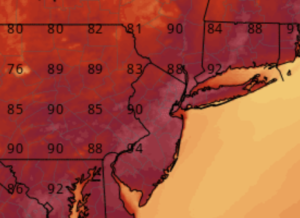
Monday: Mostly sunny skies and muggy conditions, with the chance of a brief afternoon shower or thunderstorm, are expected. Temperatures will reach into the upper 80s to mid-90s. Heat index values will approach 100 during the afternoon hours. Overnight lows will dip down into the low to mid-70s. Winds will be from the southwest at 5-10 mph.
Tuesday: More hot and humid conditions are expected as temperatures once again rise into the upper 80s to mid-90s. Heat index values will be in the low 100s for most of the region. Mostly sunny skies with the chance of scattered afternoon thunderstorms are expected. Overnight lows will be in the low to mid-70s. Winds will be from the southwest at 5-10 mph.
Wednesday: Hot and humid conditions will continue as temperatures rise into the upper 80s to mid-90s. Heat index values will be in the low 100s. Partly cloudy skies with the chance of scattered afternoon thunderstorms are expected. Overnight lows will be in the mid-60s to low 70s. Winds will be from the west at 5-10 mph.
Thursday: Widespread rain and thunderstorms are expected as a cold front moves through the region. Heavy rain and some gusty winds are possible at this time. Temperatures are expected to be in the low to mid-70s for the northern portions of the region, with upper 70s for southern areas. Overnight lows will be in the mid to upper 60s. Winds will be from the west at 5-10 mph.
Friday: Widespread rain and thunderstorms will continue before clearing out later in the day as the cold front presses southeast. Heavy rain and some gusty winds are possible at this time. Temperatures will rise into the low to mid-70s for highs. Overnight lows will dip into the low to mid-60s. Winds will be from the west at 5-10 mph.
Weekend: Once the cold front clears the region, more comfortable conditions will set up. Residual rain showers are possible early in the day Saturday for southern locations with the front still being nearby. These showers will move out early, setting us up for a dryer rest of the weekend. Temperatures will be in the mid to upper 70s with lower humidity values. Winds will be from the southwest at 5-10 mph.
-Intern Meteorologist Matt Rolph