Hazy, hot, and humid conditions return with a heat index over 100 degrees in some locations. Tropical Storm Elsa brings the threat for heavy rainfall to end the week.
A trough of low pressure will approach the region today with scattered cloud cover follow isolated showers and thunderstorms. A few thunderstorms will be capable of reach severe levels with intense downpours, frequent lightning, hail, and wind gusts over 60 mph. Winds will be from the southwest at 5 to 15 mph. Temperatures rise into the lower to mid-80s along the coast and upper 80s to lower 90s away from the coast with a heat index up to
105 degrees.
Tropical conditions will continue tonight through tomorrow with fog in the morning hours followed by scattered clouds with isolated thunderstorms in the afternoon and evening hours. The thunderstorms will be capable of intense downpours, frequent lightning, and wind gusts over 40 mph. Winds will be from the southwest at 5 to 15 mph. Temperatures tomorrow will range from the upper 60s to mid-70s for lows and lower to mid-80s along the
coast and upper 80s to mid-90s away from the coast for highs with a heat index up to 105 degrees.
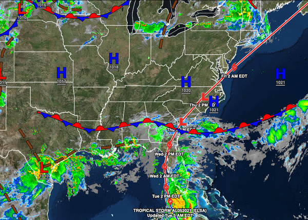
A cold front will approach from the west and Tropical Storm Elsa will approach from the south on Thursday with increasing clouds and scattered to widespread showers and thunderstorms. Winds will back to the southeast at 5 to 15 mph, increasing to 10 to 20 mph in the evening. Temperatures on Thursday will range from the upper 60s to mid-70s for lows and lower to mid-80s along the coast and upper 80s to lower 90s away from the coast for
highs.
A cold front and Tropical Storm Elsa will list through the region on Friday with widespread rainfall and windy conditions Friday morning through Friday afternoon. Temperatures on Friday will range from the upper 60s to lower 70s for lows and upper 70s to lower 80s over the interior, lower to mid-80s along the coast, and mid to upper 80s in the Delaware River Valley for highs.
A weak trough will pass through the region on Saturday with scattered to broken cloud cover and isolated showers. Temperatures on Saturday will range from the upper 50s to lower 60s over the interior and mid to upper 60s along the coast for lows and lower to mid-70s along the coast and upper 70s to mid-80s away from the coast for highs.
An area of low pressure will produce periods of rain on Sunday, heavy at times. Temperatures on Sunday will range from the lower to mid-60s over the interior and mid to upper 60s along the coast for lows and upper 60s to mid-70s for highs.
A series of cold fronts will follow on Monday and Tuesday with scattered clouds and isolated to widely scattered showers and thunderstorms. Temperatures on Monday will range from the lower to mid-60s over the interior and mid to upper 60s along the coast for lows and lower to mid-80s for highs. Temperatures on Tuesday will range from the mid to upper 60s for lows and mid-70s to lower 80s along the coast and lower to mid-80s away from the coast
for highs.