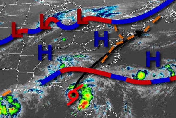
Another steamy day is expected with a heat index over 100 and a threat for thunderstorms. Tropical Storm Elsa lifts into the region by Friday with widespread heavy rainfall.
A trough will linger over the region today with areas of low clouds and fog this morning giving way to scattered clouds and isolated thunderstorms this afternoon. The thunderstorms will be capable of intense downpours, frequent lightning, hail, and wind gust up to 75 mph. Winds will be from the southwest at 5 to 15 mph. Temperatures will rise into the mid to upper 80s along the coast and upper 80s to mid-90s away from the coast with a
heat index between 95-105 degrees.
A cold front will approach tomorrow with areas of fog in the morning giving way to scattered showers and thunderstorms in the afternoon and evening hours. The thunderstorms will be capable of intense downpours, frequent lightning, hail, and wind gust up to 75 mph. Winds will back from the southwest to the southeast at 5 to 15 mph. Temperatures will range from the upper 60s to mid-70s for lows and upper 70s to lower 80s over the interior,
mid-80s to lower 90s in the Delaware River Valley, and lower to mid-80s along the coast for highs with a heat index near 100 degrees.
An advancing cold front and Tropical Storm Elsa will bring widespread heavy rainfall to the region on Friday morning into early Friday afternoon along with windy conditions. Rainfall amounts of 1" to 3" with locally higher amounts along the immediate coast can be expected along with flash flooding. Winds will back from the southeast to the northwest at 5 to 15 mph over the interior and 15 to 30 mph with gusts over 40 mph along the coast.
A few locations along the immediate coast may experience sustained winds between 40 to 45 mph for a short time with higher gusts. Flash flooding, poor visibility, and wind damage will be a threat on Friday. Temperatures will range from the upper 60s to mid-70s for lows and upper 70s to lower 80s over the interior, lower to mid-80s on the coast, and mid to upper 80s in the Delaware River Valley for highs.
The cold front will stall to the south of the region on Saturday with scattered to broken cloud cover and isolated showers. Temperatures will range from the upper 50s to lower 60s over the interior and mid to upper 60s along the coast for lows and upper 70s to mid-80s for highs.
An area of low pressure will move along the stationary front on Sunday with periods of rain throughout most of the region, scattered showers for the higher elevations. Temperatures on Sunday will range from the lower to mid-60s over the interior and mid-60s to lower 70s along the coast for lows and lower to mid-70s along the coast and mid-70s to lower 80s away from the coast for highs.
A series of weak cold fronts and troughs will pass through the region Monday through Wednesday with scattered cloud cover and isolated showers and thunderstorms. Temperatures on Monday will range from the lower to mid-60s over the interior and upper 60s to lower 70s along the coast for lows and lower to mid-80s for highs. Temperatures on Tuesday will range from the upper 60s to mid-70s for lows and mid-70s to lower 80s along the coast, lower to
mid-80s away from the coast, and mid-80s to lower 90s in the Delaware River Valley for highs. Temperatures on Wednesday will range from the lower to mid-70s for lows and lower to mid-80s over the interior and along the coast and upper 80s to lower 90s in the Delaware River Valley for highs.