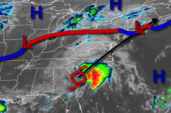
Stormy weather will dominate the region through tomorrow with the threat for thunderstorms this afternoon, Tropical Storm Elsa tomorrow morning, and a final round of thunderstorms tomorrow evening.
A trough will approach the region ahead of a strong cold front over the Ohio River Valley and Tropical Storm Elsa from the south with scattered showers and thunderstorms in the afternoon and evening. The thunderstorms will be capable of intense downpours, frequent lightning, and wind gusts over 40 mph. Winds will be from the southwest at 5 to 15 mph. Temperatures will rise into the mid-70s to lower 80s over the interior, upper 70s to
mid-80s along the coast, and mid to upper 80s in the Delaware River Valley for highs.
Tropical Storm Elsa will approach the region tonight with increasing clouds and heavy rainfall towards morning. Winds will back to the southeast at 5 to 15 mph, increasing to 10 to 20 mph along the coast. Temperatures will fall into the upper 60s to mid-70s for lows.
Tropical Storm Elsa will move through the region tomorrow morning with very heavy rainfall, especially on the coast. Rainfall amounts will range from 0.25" to 1.25" over the interior and eastern Pennsylvania, 1" to 3" along the Delaware River Valley, and 2" to 4" with locally higher amounts along the coast. Winds will back from the southeast to the northwest at 5 to 15 mph over the interior, 15 to 30 mph in the Delaware River Valley, and 20 to
40 mph with higher gusts along the immediate coast. A cold front will follow in the afternoon and evening with scattered showers and thunderstorms. A few thunderstorms may reach severe levels with intense downpours, frequent lightning, hail, and wind gusts over 65 mph. Temperatures will rise into the upper 70s to lower 80s over the interior and mid to upper 80s along the coast for highs.
The cold front will stall to the south of the region on Saturday with scattered to broken cloud cover and isolated showers. Winds will be from the northwest at 5 to 15 mph. Temperatures will range from the lower to mid-60s over the interior and upper 60s to lower 70s along the coast for lows and mid-70s to lower 80s over the interior and upper 70s to mid-80s along the coast for highs.
An area of low pressure will move through the region on Sunday with periods of scattered showers and cloudy conditions. Temperatures will range from the lower to mid-60s over the interior and upper 60s to lower 70s along the coast for lows and upper 70s to lower 80s over the interior and along the coast and mid to upper 80s in the Delaware River Valley for highs.
A series of weak troughs and cold fronts will move through the region on Monday through Thursday with scattered cloud cover and isolated to widely scattered showers and thunderstorms in the afternoon. Temperatures through the period will range from the upper 60s to mid-70s for lows and upper 70s to mid-80s along the coast, lower to mid-80s over the interior, and mid-80s to lower 90s in the Delaware River Valley for highs.