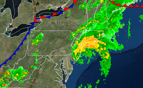
Elsa is rapidly lifting northeast towards New England this morning while a cold front advances from the west with showers and thunderstorms for this evening.
Tropical Storm Elsa will continue to rapidly lift to the northeast with heavy rainfall coming to an end from southwest to northeast through this morning into the early afternoon hours. A cold front will follow later this afternoon and evening with scattered showers and thunderstorms. A few thunderstorms will reach severe levels with intense downpours, frequent lightning, hail, and wind gusts over 60 mph. Winds will back to the northwest
at 5 to 15 mph over the interior and 10 to 20 mph along the coast. Temperatures will rise into the lower to mid-80s over the interior and mid to upper 80s along the coast for highs.
Scattered clouds are expected tonight as the cold front stalls to the south of the region. Winds will be from the northwest at 5 to 15 mph. Temperatures will fall into the lower to mid-60s over the interior and mid-60s to lower 70s along the coast for lows.
A weak trough will pass through the region tomorrow with scattered to broken cloud cover with isolated showers. Winds will be from the northwest at 5 to 15 mph. Temperatures will rise into the upper 70s to lower 80s over the interior and lower to mid-80s along the coast for highs.
An area of low pressure will approach on Sunday with scattered showers. Winds will back to the southeast at 5 to 15 mph. Temperatures on Sunday will range from the lower to mid-60s over the interior and upper 60s to lower 70s along the coast for lows and mid to upper 70s over the interior and upper 70s to lower 80s along the coast for highs.
A tropical air mass will build into the region via the Bermuda high-pressure system while a series of weak cold fronts and troughs will approach from the west producing fog in the morning and isolated showers and thunderstorms in the afternoon for Monday through Friday. The thunderstorms will be capable of intense downpours, frequent lightning, and wind gusts over 40 mph. Temperatures on Monday will range from the mid to upper 60s over the
interior and upper 60s to mid-70s along the coast for lows and upper 70s to lower 80s over the interior, lower to mid-80s along the coast, and mid to upper 80s in the Delaware River Valley for highs. Temperatures Tuesday through Friday will range from the upper 60s to mid-70s for lows and lower to mid-80s along the coast and mid-80s to lower 90s away from the coast.