Heat and humidity return this week as a Bermuda high sets up. Heat index values in the low 100s will be possible. A cold front will approach the region and bring showers and thunderstorms towards the end of the week.
Sunday: A mix of sun and clouds with scattered showers and thunderstorms is expected as a warm front moves through the region. Temperatures will be in the mid to upper 70s for northern regions while low to mid-80s can be expected for southern regions. Winds will be from the southeast at 5-10 mph.
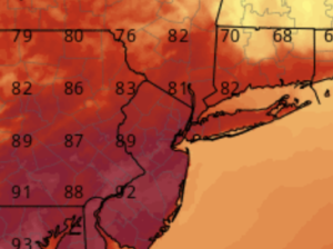
Monday: A hot and humid day is expected as southwest flow returns and increases temperatures and humidity. Mostly sunny skies with scattered afternoon thunderstorms are possible. Highs reach into the upper 80s and low 90s for the interior while upper 70s to mid-80s can be expected closer to the coast. Heat index values will be in the upper 90s to low 100s. Winds will be from the southwest at 5-10 mph.
Tuesday: Hot and humid conditions will continue as temperatures rise into the upper 80s and low 90s for the interior while mid-70s to low 80s can be expected closer to the coast. Heat index values will be in the upper 90s to mid 100s. Mostly sunny skies with an isolated afternoon thunderstorm are expected. Winds will be from the south at 5-10 mph.
Wednesday: Intervals of clouds and sun with scattered afternoon thunderstorms are expected. Temperatures will rise into the mid-80s to lower 90s for the interior while the mid-70s to the lower 80s closer to the coast. Heat index values will be in the mid-90s to near 100. Winds will be from the south at 5-10 mph.
Thursday: Mostly sunny skies with a stray afternoon thunderstorm is expected. Temperatures will be in the mid-80s to near 90 for the interior while upper 70s to mid-80s for the coast. Humidity values will be slightly lower making it feel a little more comfortable. Winds will be from the west at 5-10 mph.
Friday: Another sunny day is expected with a stray afternoon thunderstorm possible. Temperatures will be in the mid-80s to low 90s for most of the region. Humidity values will begin to creep back up as southwest flow returns, making it feel muggy. Winds will be from the southwest at 5-10 mph.
Weekend: A rather unsettled weekend is ahead as a cold front will approach the region bringing an increased chance for showers and thunderstorms. Temperatures will be in the mid-80s to near 90 for most locations while northern locations will be in the upper 70s to mid-80s on Sunday. Winds will be from the southwest at 5-10 mph.
-Intern Meteorologist Matt Rolph