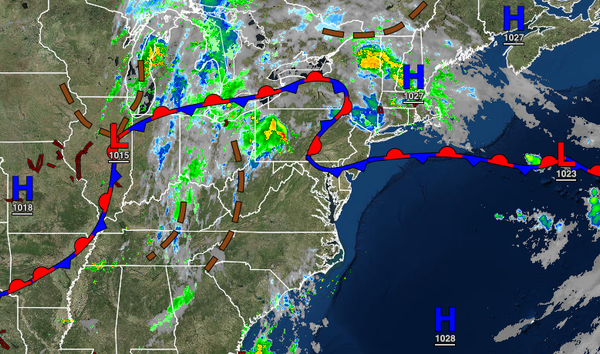
A stationary front and tropical air mass will keep unsettled conditions in place through the end of the week. More widespread rainfall is expected this weekend.
A stationary front will linger over the region with areas of locally dense fog this morning giving way to scattered to broken cloud cover and a few isolated thunderstorms, especially to the west of the Delaware River. Thunderstorms will be capable of heavy downpours, frequent lightning, and wind gusts over 40 mph. Winds will back from the southwest to the southeast at 5 to 15 mph. Temperatures will rise into the mid-70s to lower 80s over
the interior and New York City metropolitan area and mid-80s to lower 90s in the Philadelphia metropolitan area and southern New Jersey. A heat index up to 102 degrees will be a threat in the Philadelphia metropolitan area.
The stationary front will lift north tonight through Friday with fog in the morning hours and isolated showers and thunderstorms, especially away from the coast. Winds will be from the southwest at 5 to 15 mph. Temperatures tomorrow will range from the lower to mid-70s for lows and lower to mid-80s over the interior and New York City metropolitan area and mid-80s to lower 90s in the Philadelphia metropolitan area and southern New Jersey for
highs. Temperatures on Thursday will range from the lower to mid-60s over the interior and upper 60s to lower 70s along the coast for lows and lower to mid-80s over the interior and New York City metropolitan area and mid-80s to lower 90s in the Philadelphia metropolitan area and southern New Jersey for highs. Temperatures on Friday will range from the upper 60s to mid-70s for lows and lower to mid-80s along the coast and mid-80s to lower 90s away from the coast for
highs.
A cold front will slowly move through the region on Saturday and Sunday with waves of showers and thunderstorms capable of heavy downpours, frequent lightning, and wind gusts over 40 mph. Temperatures on Saturday will range from the lower to mid-70s for lows and lower to mid-80s along the coast and mid to upper 80s along the coast for highs. Temperatures on Sunday will range from the upper 60 to mid-70s for lows and upper 70s to lower 80s along
the coast and mid to upper 80s away from the coast for highs.
High pressure will be in control for Monday and Tuesday with clear skies to scattered cloud cover. Temperatures on Monday will range from the lower to mid-60s over the interior and upper 60s to mid-70s along the coast for lows and upper 70s to lower 80s over the interior, lower to mid-80s along the coast, and mid to upper 80s in the Delaware River Valley for highs. Temperatures on Tuesday will range from the lower to mid-60s over the interior
and mid to upper 60s along the coast for lows and upper 70s to lower 80s over the interior and mid to upper 80s along the coast for highs.