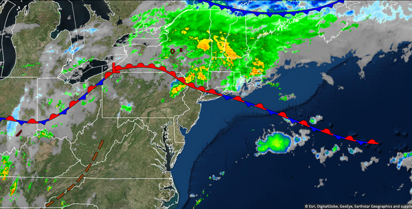
A stationary front will produce waves of showers and thunderstorms from the I-95 corridor through the interior with the threat of flash flooding through tomorrow. A tropical air mass will linger through the week.
A stationary front lingering over the region will support waves of showers and thunderstorms through tomorrow. Isolated thunderstorms will remain a threat to the south of the I-95 corridor. The thunderstorms will be capable of tropical downpours, frequent lightning, hail, and wind gusts over 40 mph. Flash flooding and significant urban flooding will be a threat today through tomorrow. Winds will be from the southwest at 5 to 15
mph. Temperatures today will rise into the lower to mid-80s over the interior and New York City metro and upper 80s to lower 90s in the Philadelphia metropolitan area and southern New Jersey with a heat index up to 105 degrees. Temperatures tomorrow will range from the upper 60s to mid-70s for lows and mid-70s to lower 80s over the interior and New York City metropolitan areas and mid-80s to lower 90s in the Philadelphia metropolitan area and southern New Jersey with a heat index up
to 105 degrees.
A weak cold front will follow on Wednesday with fog in the morning and isolated to widely scattered showers and thunderstorms in the afternoon. Winds will back to the south at 5 to 15 mph. Temperatures will range from the upper 60s to mid-70s for lows and upper 70s to mid-80s over the interior and New York City metropolitan area and upper 80s to lower 90s in the Philadelphia metropolitan area and southern New Jersey.
A stationary front will linger over the region on Thursday and Friday with fog in the morning and isolated thunderstorms in the afternoon and evening. The thunderstorms will be capable of heavy downpours, frequent lightning, and wind gusts over 40 mph. Temperatures on Thursday will range from the lower to mid-60s over the interior and upper 60s to mid-70s along the coast for lows and lower to mid-80s over the interior and mid-80s to lower 90s
along the coast for highs. Temperatures on Friday will range from the upper 60s to mid-70s for lows and lower to mid-80s over the interior and New York City metropolitan areas and upper 80s to lower 90s in the Philadelphia metropolitan area and southern New Jersey for highs.
A cold front will slowly drop through the region on Saturday and Sunday with waves of rainfall, heavy at times. Temperatures on Saturday will range from the lower to mid-70s for lows and upper 70s to lower 80s over the interior and New York City metropolitan area and mid-80s to lower 90s in the Philadelphia metropolitan area and southern New Jersey for highs. Temperatures on Sunday will range from the mid-60s to lower 70s for lows and lower to
mid-70s for highs.
High pressure will be in control on Monday with clear skies to scattered cloud cover. Temperatures will range from the upper 50s to mid-60s for lows and lower to mid80s for highs with much lower humidity.