A cold front will bring the threat for showers and thunderstorms through this weekend but not a break in the tropical conditions. A cool-down is expected, but only for the interior.
A weak trough will pass through the region this afternoon with scattered clouds and isolated showers and thunderstorms, especially over eastern Pennsylvania, the Catskills, and northwestern New Jersey. Winds will be from the south at 5 to 15 mph. Temperatures will rise into the mid-80s to lower 90s for highs with a heat index up to 103 degrees in the I-95 corridor.
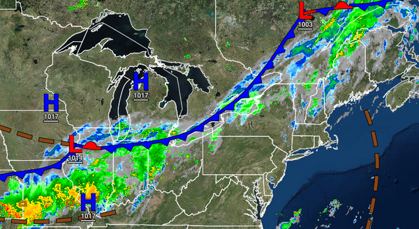
A cold front will approach tomorrow with fog and low clouds in the morning giving way to scattered showers and thunderstorms in the late afternoon and evening hours from 4 PM through midnight. Winds will be from the southwest at 5 to 15 mph. Temperatures will range from the upper 60s to mid-70s for lows and lower to mid-80s along the coast and mid-80s to lower 90s away from the coast for highs. A heat index up to 103 degrees will be
possible for the I-95 corridor.
The cold front will slowly drop through the region on Sunday with waves of low pressure producing broken to overcast cloud cover and scattered showers. Winds will veer from the southwest to the northwest at 5 to 15 mph. Temperatures will range from the lower to mid-60s over the interior and upper 60s to mid-70s along the coast for lows and lower to mid-70s for the Poconos and Catskills, upper 70s to mid-80s for the rest of the interior, lower
to mid-80s along the coast, and mid-80s to lower 90s in the Delaware River Valley for highs.
The cold front will stall over the coastal waters with waves of low-pressure Monday and Tuesday with scattered to broken cloud cover and isolated to widely scattered showers. Temperatures on Monday will range from the lower to mid-60s over the interior and upper 60s to lower 70s along the coast for lows and upper 70s to lower 80s along the coast and interior and mid to upper 80s in the Delaware River Valley for highs. Temperatures on Tuesday
will range from the mid to upper 60s for lows and lower to mid-80s over the interior and along the coast and upper 80s to lower 90s in the Delaware River Valley for highs.
A series of cold fronts will attempt to move through the region on Wednesday through Friday with scattered to broken cloud cover and isolated to widely scattered showers and thunderstorms. Temperatures on Wednesday will range from the lower to mid-60s over the interior and upper 60s to lower 70s along the coast for lows and mid-70s to lower 80s over the interior, lower to mid-80s along the coast, and mid-80s to lower 90s in the Delaware River Valley
for highs. Temperatures on Thursday will range from the upper 50s to lower 60s over the interior and mid-60s to lower 70s along the coast for lows and mid-70s to lower 80s over the interior, lower to mid-80s along the coast, and mid-80s to lower 90s in the Delaware River Valley for highs. Temperatures on Friday will range from the lower to mid-60s over the interior and upper 60s to lower 70s along the coast for lows and upper 70s to lower 80s along the coast and interior and mid-80s
to lower 90s in the Delaware River Valley for highs.