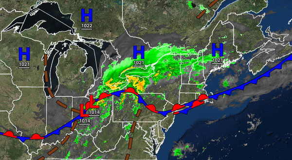
A powerful cold front will bring waves of showers and thunderstorms this evening through tomorrow morning, but not much relief from the tropical weather conditions.
A wave of low pressure will approach the region today with scattered to broken cloud cover and isolated to widely scattered showers and thunderstorms in the afternoon. Winds will veer to the southwest at 5 to 15 mph. Temperatures will rise into the mid-80s to lower 90s for highs today with a heat index up to 103 degrees in the I-95 corridor.
The wave of low pressure and the cold front will move through the region this evening through tomorrow morning with waves of showers and thunderstorms. The thunderstorms will be capable of intense downpours, frequent lightning, hail, and wind gusts over 60 mph. An isolated tornado can not be ruled out for these thunderstorms while flash flooding from intense rainfall is expected. Winds will be from the southwest at 5 to 15 mph.
Temperatures will fall into the mid-60s to lower 70s over the interior and lower to mid-70s along the coast for lows.
The cold front will stall over the coastal waters tomorrow through Tuesday with scattered to broken cloud cover and isolated showers. Winds will veer to the west-northwest at 5 to 15 mph. Temperatures tomorrow will rise into the upper 60s to mid-70s over the interior and upper 70s to lower 80s along the coast for highs. Temperatures on Monday will range from the lower to mid-60s over the interior and mid to upper 60s along the coast for
lows and upper 70s to lower 80s over the interior, lower to mid-80s along the coast, and mid to upper 80s in the Delaware River Valley for highs. Temperatures on Tuesday will range from the mid to upper 60s for lows and lower to mid-80s along the coast and higher elevations and mid to upper 80s in the Delaware River Valley for highs.
A series of weak cold fronts will follow on Wednesday through Friday with scattered cloud cover and isolated showers and thunderstorms. Temperatures on Wednesday will range from the lower to mid-60s over the interior and upper 60s to lower 70s along the coast for lows and mid-70s to lower 80s over the interior, lower to mid-80s along the coast, and mid-80s in the Delaware River Valley for highs. Temperatures on Thursday will range from the
mid-50s to lower 60s over the interior and lower to mid-60s along the coast for lows and upper 70s to lower 80s over the interior and along the coast and mid-80s in the Delaware River Valley for highs. Temperatures on Friday will range from the lower to mid-60s over the interior and upper 60s to lower 70s along the coast for lows and mid-70s to lower 80s over the interior, upper 70s to mid-80s along the coast, and mid-80s in the Delaware River Valley for highs.
High pressure will build into the region on Saturday with clear skies to scattered cloud cover. Temperatures will range from the mid-50s to lower 60s over the interior and lower to mid-60s along the coast for lows and mid-70s to lower 80s for highs.