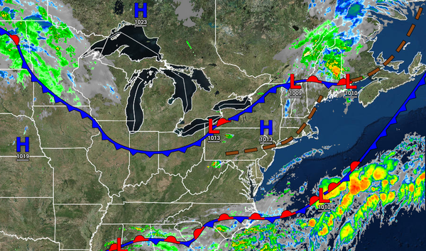
A cold front will produce showers and thunderstorms this afternoon and help clear out the smokey conditions and poor air quality throughout the region. Unsettled conditions will remain through the weekend.
A cold front will move through the region today with showers and thunderstorms from noon through 6 PM. The thunderstorms will be capable of reaching severe levels with intense downpours, frequent lightning, hail, and wind gusts up to 70 mph. Winds will veer to the northwest at 5 to 15 mph. Temperatures will rise into the lower to mid-70s for higher elevations, upper 70s to mid-80s along the coast, and lower to mid-80s in the Delaware
River Valley for highs.
A series of weaker cold fronts will pass through the region tomorrow through Friday with scattered clouds and isolated showers. Winds will be from the northwest at 5 to 15 mph. Temperatures tomorrow will range from the mid-50s to lower 60s over the interior and lower to mid-60s along the coast for lows and lower to mid-70s over the interior and upper 70s to lower 80s along the coast for highs. Temperatures on Friday will range from the
mid-50s to lower 60s over the interior and lower to mid-60s along the coast for lows and mid to upper 70s over the interior, upper 70s to lower 80s along the coast, and lower to mid-80s in the Delaware River Valley for highs.
A stationary front will linger over the coastal waters on Saturday with scattered clouds and isolated showers. Temperatures will range from the upper 50s to lower 60s over the interior and lower to mid-60s along the coast for lows and upper 70s to lower 80s over the interior, mid-70s to lower 80s along the coast, and lower to mid-80s in the Delaware River Valley for highs.
An area of low pressure will pass through the region on Sunday afternoon through Monday morning with periods of showers, heavy at times. Skies will clear on Monday afternoon. Temperatures on Sunday will range from the mid-60s to lower 70s for lows and mid-70s to lower 80s along the coast, lower to mid-80s over the interior, and mid to upper 80s in the Delaware River Valley for highs. Temperatures on Monday will range from the upper 60s to
lower 70s for lows and lower to mid-80s along the coast and higher elevations and mid to upper 80s in the Delaware River Valley for highs.
A series of weak cold fronts will follow on Tuesday and Wednesday with scattered clouds and isolated showers. Temperatures on Tuesday will range from the mid-60s to lower 70s for lows and lower to mid-80s along the coast and higher elevations and mid to upper 80s in the Delaware River Valley for highs. Temperatures on Wednesday will range from the lower to mid-60s over the interior and upper 60s to mid-70s along the coast for lows and lower to
mid-80s along the coast and mid to upper 80s away from the coast for highs.