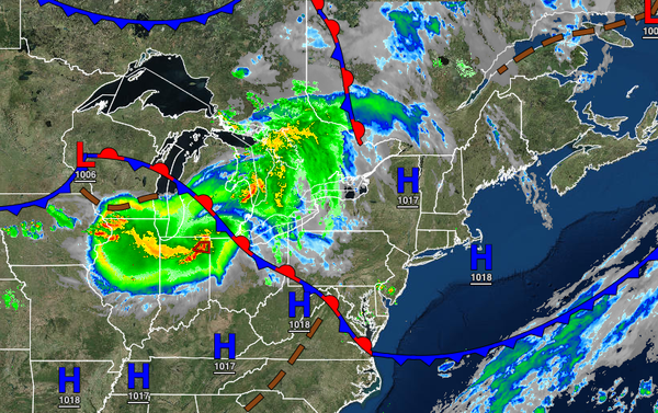
A warm front will slowly lift north today with the threat of severe thunderstorms capable of powerful wind gusts, isolated tornadoes, flash flooding, and poor visibility just in time for the rush hour. A cooler weather pattern is expected by this weekend. A wet weather pattern returns next week.
A warm front will lift north today with increasing clouds and scattered showers and thunderstorms. A few thunderstorms will reach severe levels with intense downpours, frequent lightning, wind gusts up to 75 mph, hail, and isolated tornadoes. The best potential for severe thunderstorms will be over central and southern New Jersey throughout southeastern Pennsylvania. Winds will veer to the south at 5 to 15 mph. Temperatures will
rise into the mid-70s to lower 80s over the interior and New York City metropolitan area and lower to mid-80s in the Philadelphia metropolitan area for highs.
A cold front will follow tonight through tomorrow with scattered showers and thunderstorms. Winds will veer from the southwest to the northwest at 5 to 15 mph. Temperatures will fall into the upper 50s to lower 60s over the interior and mid-60s to lower 70s along the coast for lows.
The cold front will exit tomorrow with scattered clouds and isolated showers through the afternoon followed by clearing skies. Winds will be from the northwest at 5 to 15 mph. Temperatures will rise into the lower to mid-70s over the interior, upper 70s to lower 80s in the New York City metropolitan area, and lower to mid-80s in the Philadelphia metropolitan area for highs.
High pressure will build into the region on Saturday with clear skies to scattered clouds. Winds will be from the northwest at 5 to 15 mph. Temperatures will range from the upper 40s to mid-50s over the interior and mid-50s to lower 60s along the coast for lows and lower to mid-70s over the interior and mid-70s to lower 80s along the coast and in the Delaware River Valley for highs.
High pressure will exit on Sunday while another warm front approaches with increasing clouds and isolated showers by evening. Temperatures will range from the upper 50s to lower 60s for lows and mid-70s to lower 80s along the coast and upper 70s to mid-80s away from the coast for highs.
A series of weak cold fronts will move through the region Monday through Wednesday with isolated to widely scattered showers. Temperatures on Monday will range from the upper 50s to mid-60s for lows and mid-70s to lower 80s along the coast, upper 70s to mid-80s over the interior, and lower to mid-80s in the Delaware River Valley for highs. Temperatures on Tuesday will range from the upper 50s to mid-60s for lows and upper 70s to lower 80s for
highs. Temperatures on Wednesday will range from the upper 50s to mid-60s for lows and upper 70s to mid-80s along the coast and over the interior and mid to upper 80s in the Delaware River Valley for highs.
A stationary boundary and waves of low pressure will produce scattered to widespread showers and thunderstorms on Thursday. The rainfall will be heavy at times. Temperatures will range from the lower to mid-60s over the interior and mid to upper 60s along the coast for lows and upper 70s to lower 80s for highs.