Excellent weather will be in place to start the week but rainfall will return by the end of the week as an unsettled weather pattern redevelops.
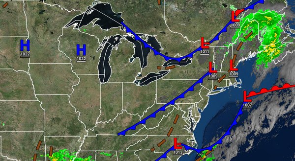
A cold front will clear the region this morning followed by high-pressure building into the region through this evening. Winds will be from the northwest at 5 to 15 mph. Temperatures will rise into the lower to mid-70s over the interior and upper 70s to lower 80s in the Delaware River Valley and along the coast for highs.
High pressure will pass over the region tonight through tomorrow with clear skies to scattered cloud cover. Winds will veer from the north to northeast at 5 to 15 mph. Temperatures will range from the lower to mid-50s over the interior and upper 50s to lower 60s along the coast for lows and upper 70s to lower 80s for highs.
A warm front over the Atlantic Ocean and trough of low pressure will approach on Wednesday with increasing clouds and isolated showers. Winds will be from the east at 5 to 15 mph. Temperatures will range from the lower to mid-60s for lows and mid to upper 70s for highs.
An area of low pressure along the coast will produce periods of rain on Thursday in the afternoon and evening hours. The rainfall is expected to be heaviest along the coast with up to 1.50" of rain possible. Temperatures will range from the upper 50s to mid-60s for lows and mid-70s for highs.
The stationary front will linger over the region's coastal waters on Friday with widely scattered showers. Temperatures will range from the lower to mid-60s over the interior and upper 60s to lower 70s along the coast for lows and upper 70s to mid-80s for highs.
A series of weak troughs will linger over the region on Saturday through Monday with scattered to broken cloud cover and isolated showers and thunderstorms. An increase in humidity can be expected with each day. Temperatures on Saturday will range from the mid-60s to lower 70s for lows and lower to mid-80s for highs. Temperatures on Sunday will range from the lower to mid-60s over the interior and upper 60s to lower 70s along the coast
for lows and lower to mid-80s along the coast, mid to upper 80s over the interior, and upper 80s to lower 90s in the Delaware River Valley for highs. Temperatures on Monday will range from the upper 60s to lower 70s for lows and mid to upper 80s along the coast, upper 80s to lower 90s over the interior, and lower to mid-90s in the Delaware River Valley for highs.