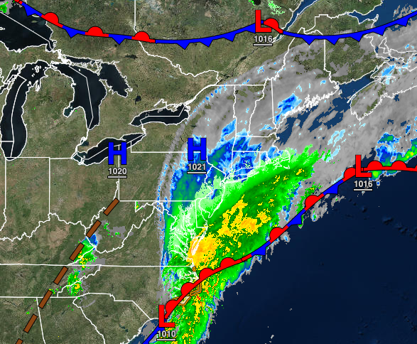
A wave of low pressure along the North Carolina coast will bring waves of rainfall to Long Island this evening and scattered showers to the coast. A tropical weather pattern returns this weekend through next week.
An area of low pressure will lift towards the coastal waters today through tonight with overcast skies throughout the region. Isolated to widely scattered showers can be expected over the interior, scattered showers from the Delaware River to the New Jersey coast and New York City metropolitan area, and periods of moderate to heavy rainfall over Long Island and southeastern Connecticut. The heavy rainfall will produce rainfall totals of 0.5" to
1.5" of rain, especially towards the east end of Long Island. The bulk of the rainfall is for this evening through early tomorrow morning. Winds will back from the east to the northeast at 5 to 15 mph. Temperatures will range from the lower to mid-70s for highs.
The stationary front will linger over the coastal waters tomorrow through Friday with scattered to broken clouds and isolated showers. Winds will back from the northwest to the southwest at 5 to 15 mph. Temperatures tomorrow will range from the mid to upper 50s over the interior and lower to mid-60s along the coast for lows and upper 70s to lower 80s over the interior, lower to mid-80s along the coast, and mid to upper 80s in the Delaware River
Valley for highs. Temperatures on Friday will range from the lower to mid-60s for lows and lower to mid-80s along the coast and mid-80s to lower 90s away from the coast for highs.
A tropical air mass will begin to build into the region Saturday through Tuesday as the Bermuda high-pressure system builds to the coast and weak troughs linger over the region producing areas of fog in the morning, isolated thunderstorms in the afternoon, and muggy conditions. Temperatures on Saturday and Sunday will range from the mid-60s to lower 70s for lows and upper 70s to mid-80s along the coast and mid-80s to lower 90s away from the coast for
highs. Temperatures on Monday will range from the upper 60s to lower 70s for lows and upper 70s to mid-80s along the coast, mid to upper 80s over the interior, and upper 80s to mid-90s in the Delaware River Valley for highs. Temperatures on Tuesday will range from the lower to mid-70s for lows and mid to upper 80s along the coast, upper 80s to lower 90s over the interior, and lower to mid-90s in the Delaware River Valley for highs. A heat index over 95 degrees will be a threat
in the afternoon hours, especially for early next week.
A strong cold front will follow on Thursday with scattered showers and thunderstorms. The thunderstorms may reach severe levels. Temperatures will range from the upper 60s to lower 70s over the interior and lower to mid-70s along the coast for lows and lower to mid-80s over the interior, mid-80s to lower 90s along the coast, and upper 80s to mid-90s in the Delaware River Valley for highs. The high temperatures will be dependent on the
timing of the cold front and the development of thunderstorms over the region.