After an area of low pressure brings rainfall to the coastal regions tonight, a tropical air mass returns with the threat of morning fog, afternoon thunderstorms, and an elevated heat index.
High pressure will exit today with increasing clouds through this afternoon. Winds will be from the southeast at 5 to 15 mph. Temperatures will rise into the lower to mid-80s for highs this afternoon.
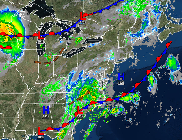
An area of low pressure will pass through the coastal waters this evening through tomorrow morning with overcast skies and isolated showers over the interior, scattered showers in the Delaware River Valley, and periods of rain along the immediate coast and Long Island. Rainfall amounts over 1" will be possible for the immediate coast, especially southern New Jersey. Winds will back from the southeast to the southwest at 5 to 15 mph.
Temperatures will fall into the lower to mid-60s for lows.
The low-pressure system will depart tomorrow with clearing skies and a few isolated showers. Winds will back to the south at 5 to 15 mph. Temperatures tomorrow afternoon will rise into the mid-70s to lower 80s along the coast and lower to mid-80s away from the coast for highs.
High pressure will build into the region from the Atlantic Ocean with scattered cloud cover and isolated showers on Monday. Winds will be from the south at 5 to 15 mph. Temperatures will range from the mid to upper 60s for lows and upper 70s to mid-80s along the coast and mid to upper 80s away from the coast for highs.
A tropical air mass will be in place on Tuesday through Thursday with areas of fog in the morning and scattered clouds with isolated thunderstorms in the afternoon. The thunderstorms will be capable of intense downpours, frequent lightning, and wind gusts over 40 mph. The thunderstorms will be capable of flash flooding and wind damage. Temperatures through the period will range from the mid-60s to the mid-70s away from urban areas and mid
to upper 70s in urban areas for lows and upper 70s to mid-80s along the coast, mid-80s to lower 80s over the interior, and upper 80s to mid-90s in the Delaware River Valley for highs. A heat index over 95 degrees will be likely through this period.
A strong cold front will move through the region on Friday with areas of fog in the morning and scattered showers and thunderstorms in the afternoon and evening. The thunderstorms will be capable of intense downpours, frequent lightning, hail, and wind gusts over 40 mph. Severe thunderstorms will be a threat. Temperatures on Friday will range from the lower to mid-70s over the interior and mid to upper 70s along the coast for lows and
lower to mid-80s along the coast, mid to upper 80s over the interior, and upper 80s to lower 90s in the Delaware River Valley for highs.
High pressure will build into the region on Saturday with clearing skies and falling humidity. Temperatures will range from the lower to mid-60s over the interior and upper 60s to mid-70s along the coast for lows and lower to mid-70s over the interior and upper 70s to mid-80s along the coast for highs.