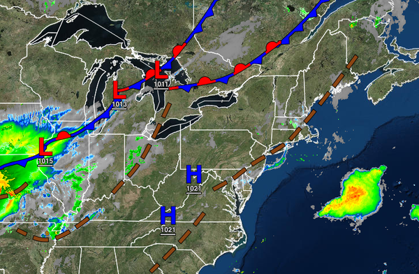
Dangerous hot and humid conditions continue today with a heat index rising over 100 degrees. A powerful cold front will follow tomorrow afternoon, ending the heatwave with strong and severe thunderstorms.
A tropical air mass will remain in place over the region today with fog a threat in the morning and isolated to widely scattered thunderstorms, especially in the afternoon hours. The fog will have the potential to be locally dense with visibility below a mile. The thunderstorms will be capable of torrential downpours, frequent vivid lightning, hail, and wind gusts up to 75 mph. The thunderstorms will have the potential to produce flash
flooding and wind damage. Winds will be from the south at 5 to 10 mph. Temperatures this afternoon will rise into the mid to upper 80s along the coast, upper 80s to lower 90s over the interior, and lower to mid-90s in the Delaware River Valley for highs. A heat index of 95 to 110 degrees will be a threat in the afternoon hours.
A cold front will slowly sink through the region tomorrow with widespread showers and thunderstorms in the afternoon and evening. The thunderstorms will have the potential to reach severe levels with intense downpours, frequent lightning, large hail, wind gusts over 65 mph, and isolated tornadoes. Winds will veer from the south to the northwest at 5 to 15 mph. Temperatures tomorrow will range from the upper 60s to lower 70s over the
interior and lower to mid-70s along the coast for lows and mid-70s to lower 80s over the interior and mid-80s to lower 90s along the coast and in the Delaware River Valley.
The cold front will stall to the south of the region on Sunday with scattered clouds and isolated showers. Winds will veer from the northwest to the northeast at 5 to 10 mph. Temperatures will range from the mid-50s to lower 60s over the interior and mid-60s to lower 70s along the coast for lows and upper 70s to lower 80s over the interior and lower to mid-80s along the coast and Delaware River Valley for highs.
High pressure will pass through New England producing an onshore flow and scattered cloud cover. An isolated shower is possible, but mostly dry conditions are expected on Monday. Temperatures will range from the mid-50s to lower 60s over the interior and lower to mid-60s along the coast for lows and lower to mid-80s for highs.
A stationary front to the south of the region will produce scattered to broken cloud cover and isolated showers on Tuesday and Wednesday. Temperatures on Tuesday will range from the mid to upper 60s for lows and upper 70s to mid-80s for highs. Temperatures on Wednesday will range from the upper 60s to lower 70s for lows and mid to upper 70s over the interior and upper 70s to lower 80s along the coast for highs.
The remnants of Fred and a warm front will produce waves of rainfall, heavy at times, on Thursday and Friday. Temperatures on Thursday will range from the upper 60s to mid-70s for lows and upper 70s to lower 80s for highs. Temperatures on Friday will range from the upper 60s to mid-70s for lows and lower to mid-80s for highs.