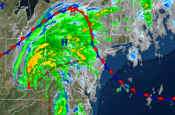
The remnants of Fred will lift into the region with heavy rainfall expected for the higher elevations while a tropical air mass lingers throughout the region into next week.
A warm front will continue to lift north today while the remnants of Fred approaches the region with broken to overcast cloud cover and isolated to widely scattered showers. The showers will be capable of brief heavy downpours at times. Winds will veer to the south at 5 to 15 mph. Temperatures will rise into the upper 70s to lower 80s over the interior and along the coast and mid to upper 80s in the Delaware River Valley for
highs.
The remnants of Fred will lift through the region tonight with periods of rain, heavy at times over the Poconos, Catskills, and northwestern New Jersey while scattered showers will be a threat throughout the rest of the region. The showers will be capable of heavy tropical downpours and localized urban flooding. Rainfall amounts in the Poconos and Catskills will range from one to three inches with locally higher amounts possible. Winds
will be from the southwest at 5 to 15 mph. Temperatures will fall into the lower to mid-70s for lows.
The remnants will exit by tomorrow morning with lingering isolated to widely scattered showers along with scattered cloud cover can be expected throughout the day. Winds will be from the southwest at 5 to 15 mph. Temperatures will rise into the lower to mid-80s over the interior and mid to upper 80s along the coast and Delaware River Valley for highs.
A weak trough will pass through the region on Friday with scattered clouds and isolated to widely scattered showers. Winds will be from the south at 5 to 15 mph. Temperatures will range from the mid to upper 60s over the interior and upper 60s to lower 70s along the coast for lows and upper 70s to lower 80s over the interior and lower to mid-80s along the coast and Delaware River Valley for highs.
An inverted trough will produce widespread showers to scattered showers, heavy at times, on Saturday and Sunday. Temperatures will range from the mid to upper 60s over the interior and lower to mid-70s along the coast for lows and mid-70s to lower 80s over the interior, upper 70s to lower 80s along the coast, and lower to mid-80s in the Delaware River Valley for highs.
A series of cold fronts will pass through the region on Monday through Wednesday with scattered clouds and isolated showers and thunderstorms. The thunderstorms will be capable of brief heavy downpours, frequent lightning, and wind gusts over 40 mph. Temperatures through the period will range from the mid to upper 60s over the interior, upper 60s to lower 70s along the coast, and lower to mid-70s in the Delaware River Valley and urban areas for
lows and upper 70s to lower 80s over the interior and along the coast and mid to upper 80s in the Delaware River Valley for highs.