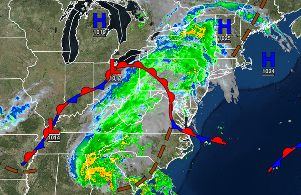
A warm front will lift north today as the leading edge of a tropical air mass invades. The remnants of Fred will follow by tomorrow night with waves of heavy rainfall by Thursday morning. An active pattern continues into next week.
A warm front will lift north today with cloudy skies and isolated to scattered showers throughout the region. Winds will veer from the southeast to the south at 5 to 15 mph. Temperatures will rise into the mid-70s to lower 80s throughout the region for highs.
The warm front will stall to the north of the region with broken to overcast skies and isolated to scattered showers tonight through tomorrow. Winds will be from the south at 5 to 15 mph. Temperatures tomorrow will range from the upper 60s to mid-70s for lows and mid-70s to lower 80s over the interior, upper 70s to mid-80s along the coast, and mid-80s to lower 90s in the Delaware River Valley for highs.
The remnants of Fred will lift through the region tomorrow night through Thursday with periods of moderate to heavy rainfall through the morning hours giving way to scattered showers in the afternoon and evening. The heaviest rainfall of 1" to 3" can be expected from the I-95 corridor to the northwest while less rainfall, between 0.25" to 1.25" can be expected for the New Jersey coast and Long Island. Poor visibility and areas of flash
flooding, especially in the Poconos and Catskills, can be expected. Winds will veer from the southwest to west at 5 to 15 mph with gusts over 30 mph at times in heavy downpours. Temperatures will range from the upper 60s to mid-70s for lows and lower to mid-70s over the interior and upper 70s to mid-80s along the coast and in the Delaware River Valley.
A series of weak troughs will follow on Friday, Saturday, and Sunday with scattered clouds and isolated to widely scattered showers capable of brief heavy downpours. Temperatures will range from the mid to upper 60s over the interior and upper 60s to lower 70s along the coast for lows and upper 70s to lower 80s over the interior and along the coast and lower to mid-80s in the Delaware River Valley for highs.
A series of cold fronts will follow on Monday and Tuesday with scattered clouds and isolated to widely scattered showers and thunderstorms. Temperatures on Monday will range from the mid to upper 60s over the interior and upper 60s to lower 70s along the coast for lows and upper 70s to lower 80s over the interior and along the coast and mid to upper 80s in the Delaware River Valley for highs. Temperatures on Tuesday will range from the lower to
mid-60s over the interior and upper 60s to lower 70s along the coast for lows and upper 70s to lower 80s over the interior, lower to mid-80s along the coast, and mid to upper 80s in the Delaware River Valley for highs.