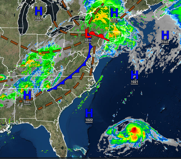
The remnants of Fred are rapidly lifting through the region this morning with reports of flash flooding and a few tornado warnings. Meanwhile, all eyes are on Tropical Storm Henri as the storm will come a bit too close for comfort by Sunday afternoon.
The remnants of Fred will continue to lift through the region this morning with heavy rain and embedded strong and severe thunderstorms over the interior and New York City metropolitan areas. Scattered clouds with a few lingering isolated showers will remain a threat through this afternoon. Winds will be from the southwest at 5 to 15 mph. Temperatures will rise into the upper 70s to lower 80s over the interior, lower to mid-80s along the
coast, and mid to upper 80s in the Delaware River Valley.
A weak trough will approach tonight through tomorrow with scattered cloud cover and isolated showers. Winds will be from the south at 5 to 15 mph. Temperatures will range from the mid to upper 60s over the interior and lower to mid-70s along the coast for lows and upper 70s to mid-80s for highs.
An inverted trough will develop over the region tomorrow night into Saturday with periods of rain, heavy at times, especially on Saturday afternoon. Winds will back to the southeast at 5 to 15 mph with gusts up to 30 mph at times. Temperatures will range from the mid to upper 60s over the interior and lower to mid-70s along the coast for lows and upper 70s to lower 80s for highs.
The trough will continue to linger over the region on Sunday while Tropical Storm Henri, possibly a hurricane by Sunday, will track well to the east of the region. At this time, Henri is expected to impact southern New England by the evening hours, however, the storm will be close enough to produce coastal flooding and some beach erosion. Meanwhile, periods of rain will continue to rotate through the region due to the trough. Temperatures
on Sunday will range from the mid-60s to lower 70s for lows and upper 70s to lower 80s for highs.
The exact track of Henri is still in question and any shift to the west or east would have a significant impact on the region for Sunday afternoon through Monday morning. As such, interest should continue to monitor the development of Henri over the next few days. The stronger Henri is, the further west Henri will be able to track.
A series of weak troughs and cold fronts will pass through the region on Monday through Thursday with areas of fog in the morning and scattered clouds with isolated to widely scattered showers and thunderstorms in the afternoon. Temperatures on Monday will range from the mid-60s to lower 70s for lows and upper 70s to lower 80s along the coast and lower to mid-80s away from the coast for highs. Temperatures Tuesday through Thursday will range
from the mid to upper 60s over the interior and upper 60s to lower 70s along the coast for lows and upper 70s to mid-80s along the coast, lower to mid-80s over the interior, and mid-80s to lower 90s in the Delaware River Valley for highs.