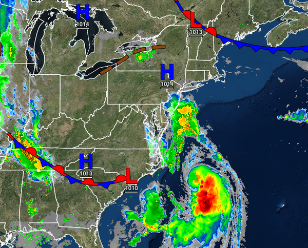
[caption id="attachment_137761" align="aligncenter" width="631"] From WeatherTap[/caption]
Henri will approach the region today and has a chance to become a hurricane before making landfall tomorrow afternoon on Long Island. A tropical air mass will linger through next week with the threat of flash flooding.
TODAY
Tropical Storm Henri will approach the coastal waters today with increasing clouds and showers developing throughout the day, especially along the coast. The showers will be capable of tropical downpours with rainfall rates around 1" per hour possible. Winds will back from the southeast to the northeast at 5 to 15 mph. Temperatures will rise into the upper 70 to mid-80s for highs.
TONIGHT
Henri, possibly a hurricane, will lift towards eastern Long Island tonight with isolated to widely scattered showers over the interior and scattered to widespread showers along the coast tonight through tomorrow morning. Winds will be from the northeast at 5 to 15 mph over the interior and 10 to 20 mph along the coast with gusts over 30 mph at times. Temperatures will fall into the mid to upper 60s over the interior and lower to mid-70s along the coast for
lows.
TOMORROW
Henri will lift through eastern Long Island and move into Connecticut tomorrow with a landfall expected around 2 PM. Henri will produce tropical storm to hurricane conditions from central New Jersey through the New York City metropolitan area, Long Island, and Connecticut with intense downpours, isolated tornadoes, frequent lightning, sustained winds of 30 to 75 mph with gusts over 75 mph at times. Coastal flooding will be a threat with a storm surge of 1 to 3 feet along
the New Jersey coast and 2 to 5 feet for Long Island and Connecticut.
The rest of the region can expect scattered showers and thunderstorms capable of tropical downpours, frequent lightning, wind gusts over 40 mph, and isolated tornadoes. Winds will back from the northeast to the northwest at 15 to 30 mph with gusts over 40 mph at times. Temperatures will rise into the mid to upper 70s for highs.
MONDAY
Henri will weaken tomorrow night through Monday will lifting towards the central Hudson River Valley and then towards New England while under the influence of the upper-level low-pressure system, which will produce scattered showers and thunderstorms throughout the region. The thunderstorms will be capable of tropical downpours with rainfall rates over 1" per hour, frequent lightning, and wind gusts over 40 mph. Winds will back to the west at 5 to 15 mph with gusts over 20
mph at times. Temperatures range from the upper 60s to mid-70s for lows and upper 70s to lower 80s for highs.
TUESDAY-FRIDAY
A series of troughs and cold fronts will pass through the region Tuesday through Friday with scattered cloud cover with isolated to widely scattered showers and thunderstorms, especially in the afternoon. Fog will be a threat in the morning hours. Temperatures will range from the upper 60s to lower 70s over the interior and lower to mid-70s along the coast for lows and lower to mid-80s over the interior and along the coast and upper 80s to lower 90s in the Delaware River
Valley for highs.
SATURDAY
High pressure will build into the region on Saturday with clear skies to scattered cloud cover. Temperatures will range from the upper 60s to lower 70s for lows and mid to upper 70s over the interior, upper 70s to lower 80s along the coast, and lower to mid-80s in the Delaware River Valley for highs.