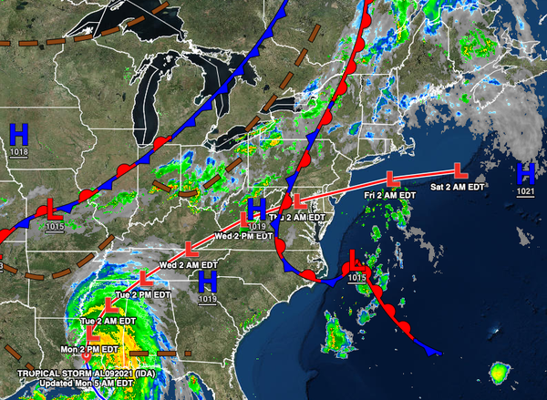
Dense fog this morning will give way to widely scattered thunderstorms by this evening. The remnants of Ida will bring heavy rainfall and flash flooding by Wednesday with rainfall amounts over 3" expected. A cool weather pattern sets in by next weekend.
TODAY
A warm front will lift through the region today with locally dense fog, low clouds, and drizzle giving way to scattered clouds by this afternoon. Winds will veer from the southeast to the southwest at 5 to 15 mph. Temperatures will rise into the upper 70s to lower 80s over the interior, lower to mid-80s along the coast, and mid to upper 80s in the Delaware River Valley for highs.
THIS EVENING THROUGH TONIGHT
A cold front will follow this evening through tomorrow morning with widely scattered showers and thunderstorms. Winds will veer from the southwest to the northwest at 5 to 15 mph. Temperatures will fall into the lower to mid-60s over the interior and upper 60s to lower 70s along the coast for lows.
TOMORROW
High pressure will produce clear skies to scattered cloud cover. Winds will be from the northwest at 5 to 15 mph. Temperatures will rise into the upper 70s to lower 80s over the interior and lower to mid-80s along the coast for highs.
TOMORROW NIGHT THROUGH WEDNESDAY
The remnants of Ida will approach the region tomorrow night through Wednesday with waves of moderate to heavy rainfall. Rainfall amounts of 1" to 3" are expected. Winds will back from the northwest to southeast at 10 to 20 mph with gusts over 30 mph at times. Temperatures will range from the lower to mid-60s over the interior and upper 60s to lower 70s along the coast for lows and mid to upper 70s for highs.
THURSDAY
The remnants of Ida will exit the region with periods of rain in the morning giving way to scattered showers in the afternoon and evening. Rainfall amounts of another 1" to 3" are expected. Winds will back to the northwest at 10 to 20 mph with gusts over 30 mph. Temperatures will range from the upper 50s to mid-60s for lows and mid to upper 60s over the interior and lower to mid-70s along the coast for highs.
FRIDAY THROUGH MONDAY
High pressure will be in control with a few weak cold front passages from time to time, but no rainfall is expected. Clear skies to scattered clouds with low humidity are expected. Temperatures on Friday and Saturday will range from the upper 40s to mid-50s over the interior and upper 50s to lower 60s along the coast for lows and mid-60s to lower 70s over the interior, lower to mid-70s along the coast, and mid to upper 70s in the Delaware River Valley
for highs. Temperatures on Sunday will range from the upper 50s to lower 60s for lows and lower to mid70s over the interior, mid to upper 70s along the coast, and upper 70s to lower 80s in the Delaware River Valley for highs. Temperatures on Monday will range from the upper 50s to lower 60s over the interior and mid to upper 60s along the coast for lows and lower to mid-70s over the interior and upper 70s to lower 80s along the coast and in the Delaware River Valley for highs.