Ida's remnants will bring waves of rainfall through tomorrow morning leading to significant flash flooding for much of the region as rainfall totals will top over 6" in some locations. A fresh, cool weather pattern settles in for Labor Day Weekend.
TODAY
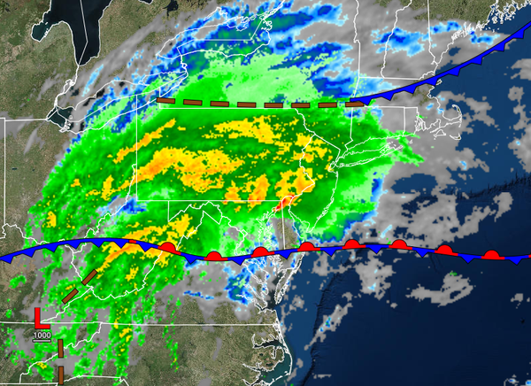
The remnants of Ida will approach the region today with periods of rain for much of the region and scattered showers and thunderstorms over southern New Jersey. The thunderstorms will be capable of intense downpours, frequent lightning, wind gusts over 40 mph, and isolated tornadoes. Winds will back from the southeast to the northeast at 5 to 15 mph. Temperatures will rise into the mid-60s to lower 70s over the interior, mid to upper 70s along
the coast, and mid-70s to lower 80s in the Delaware River Valley for highs.
TONIGHT
The remnant low-pressure system will pass through southern New Jersey into the coastal waters with waves of very intense rainfall along and north of the I-95 corridor and moderate to heavy rainfall over southern New Jersey. Flash flooding will be a high threat for the entire region, but especially in the Poconos, Catskills, Hudson River Valley, and northwestern New Jersey where over 6" of rain will be possible. Winds will back from the northeast to the
northwest at 10 to 20 mph with gusts over 40 mph at times. Temperatures will fall into the lower to mid-50s over the interior and upper 50s to lower 60s along the coast for lows.
TOMORROW
The low-pressure system will exit with showers exiting the region from west to east through the morning hours. Skies will clear in the afternoon and evening. Winds will be from the northwest at 10 to 20 mph with gusts over 25 mph at times. Temperatures will rise into the upper 60s to lower 70s over the interior and lower to mid-70s along the coast for highs.
Rainfall amounts from this storm are expected to range from 0.5" to 1.5" for extreme southern New Jersey, 1.5" to 3" for southwestern and south-central New Jersey, 3" to 6" along the I-95 corridor, and 4" to 8" to the north and northwest of the I-95 corridor including all of the interior. However, individual thunderstorms could enhance rainfall totals above the expected range. Flash flooding and urban flooding will be a high threat. Some
basements may be overwhelmed due to sewer or well backup issues.
Wind gusts will have the potential to exceed 40 mph tonight through tomorrow morning which may produce wind damage, downed trees, and power outages.
Visibility this evening through tomorrow morning will be below a mile at times.
TOMORROW NIGHT THROUGH FRIDAY
High pressure will build into the region with clear skies to scattered cloud cover. Winds will be from the northwest at 10 to 20 mph, subsiding to 5 to 15 mph in the afternoon. Temperatures will range from the lower to mid-50s over the interior and upper 50s to lower 60s along the coast for lows and upper 60s to lower 70s over the interior and lower to mid-70s along the coast for highs.
SATURDAY AND SUNDAY
High pressure will produce clear skies to scattered clouds. Temperatures on Saturday will range from the mid-50s to lower 60s for lows and lower to mid-70s over the interior and mid to upper 70s along the coast for highs. Temperatures on Sunday will range from the lower to mid-60s over the interior and mid to upper 60s along the coast for lows and mid to upper 70s over the interior and upper 70s to lower 80s along the coast for highs.
SUNDAY NIGHT THROUGH LABOR DAY MONDAY
A cold front will pass through the region with scattered to broken clouds and isolated showers Sunday night through Monday morning. Scattered clouds are expected in the afternoon. Temperatures will range from the lower to mid-60s over the interior and upper 60s to lower 70s along the coast for lows and mid to upper 70s over the interior and upper 70s to lower 80s along the coast for highs.
TUESDAY
High pressure will produce clear skies to scattered cloud cover. Temperatures will range from the lower to mid-60s over the interior and mid to upper 60s along the coast for lows and mid to upper 70s over the interior, upper 70s to lower 80s along the coast, and lower to mid-80s in the Delaware River Valley for highs.
WEDNESDAY
A weak cold front will produce a few isolated showers. Temperatures will range from the lower to mid-60s over the interior and upper 60s to lower 70s along the coast for lows and lower to mid-70s over the interior and upper 70s to lower 80s along the coast and Delaware River Valley for highs.