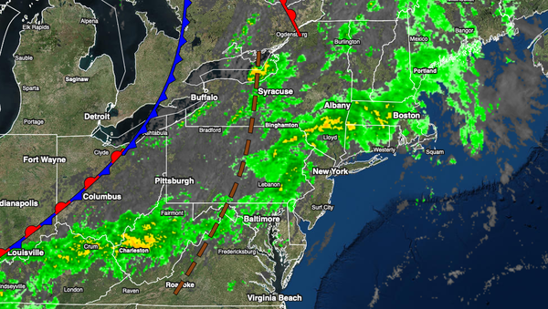
A cold front will produce scattered showers today but dry weather will return by tomorrow. Seasonable weather conditions are expected to continue into next week.
TODAY
A cold front will approach the region today with increasing clouds and scattered showers. Winds will be from the southwest at 5 to 10 mph. Temperatures will rise into the upper 60s to mid-70s over the interior, lower to mid-70s along the coast, and upper 70s to lower 80s in the Delaware River Valley for highs.
TONIGHT
The cold front will move through the region with scattered showers expected. Winds will veer from the southwest to the west at 5 to 10 mph. Temperatures will fall into the mid-50s to lower 60s over the interior and mid to upper 60s along the coast for lows.
LABOR DAY MONDAY
High pressure will build into the region with clearing skies. Winds will be from the west at 5 to 10 mph. Temperatures will rise into the lower to mid-70s over the interior and upper 70s to lower 80s along the coast for highs.
TUESDAY
High pressure will exit the region with increasing cloud cover expected. Winds will back to the southwest at 5 to 15 mph. Temperatures will range from the lower to mid-50s over the interior and upper 50s to lower 60s along the coast for lows and lower to mid-70s over the interior, mid to upper 70s along the coast, and upper 70s to lower 80s in the Delaware River Valley for highs.
WEDNESDAY THROUGH THURSDAY
A cold front will slowly move through the region Wednesday afternoon through Thursday morning with scattered showers. Skies will clear towards Thursday afternoon and evening. Temperatures on Wednesday will range from the lower to mid-60s over the interior and upper 60s to lower 70s along the coast for lows and upper 70s to lower 80s over the interior and along the coast and mid to upper 80s in the Delaware River Valley for highs. Temperatures on
Thursday will range from the lower to mid-60s over the interior and mid to upper 60s along the coast for lows and lower to mid-70s over the interior and mid to upper 70s along the coast for highs.
FRIDAY THROUGH SUNDAY
High pressure will pass through the region through the forecast period with clear skies to scattered cloud cover. Temperatures on Friday will range from the lower to mid-50s over the interior and upper 50s to lower 60s along the coast for lows and upper 60s to lower 70s over the interior and mid to upper 70s along the coast for highs. Temperatures on Saturday will range from the upper 40s to lower 50s over the interior and mid-50s to lower 60s along
the coast for lows and upper 60s to lower 70s over the interior and mid to upper 70s along the coast for highs. Temperatures on Sunday will range from the upper 50s to lower 60s over the interior and mid to upper 60s along the coast for lows and mid to upper 70s over the interior, upper 70s to lower 80s along the coast, and lower to mid-80s in the Delaware River Valley for highs.