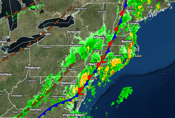
A stalling cold front with waves of low pressure will produce periods of rain, heavy at times today. Pleasant conditions return in time for the weekend. Unsettled conditions for next week.
TODAY
A slow-moving cold front with waves of low pressure will produce overcast skies and periods of rain through this evening. The heaviest rainfall is expected along the coast, but a few showers capable of heavy downpours remain a threat for the interior. Winds will veer to the west at 5 to 15 mph. Temperatures will rise into the mid to upper 60s over the interior and lower to mid-70s along the coast for highs.
TONIGHT
The cold front will push off the coast with lingering showers in the evening followed by clearing skies towards midnight. Winds will veer to the northwest at 5 to 15 mph. Temperatures will fall into the mid to upper 50s over the interior and lower to mid-60s along the coast for lows.
TOMORROW
High pressure will build into the region with clear skies to scattered cloud cover. Winds will be from the northwest at 5 to 15 mph. Temperatures will rise into the mid to upper 60s over the interior and lower to mid-70s along the coast for highs.
SATURDAY AND SUNDAY
High pressure will pass through the region with clear skies to scattered cloud cover. Winds will be from the southwest at 5 to 15 mph. Temperatures on Saturday will range from the upper 40s to lower 50s over the interior and mid to upper 50s along the coast for lows and lower to mid-70s for highs. Temperatures on Sunday will range from the upper 50s to lower 60s over the interior and mid to upper 60s along the coast for lows and upper 70s to
lower 80s over the interior and along the coast and lower to mid-80s in the Delaware River Valley for highs.
MONDAY
A cold front will drop through the region with widely scattered showers and isolated thunderstorms. Temperatures will range from the mid to upper 60s for lows and mid-70s to lower 80s over the interior, upper 70s to mid-80s along the coast, and mid to upper 80s in the Delaware River Valley for highs.
TUESDAY THROUGH THURSDAY
The cold front boundary will stall and waver over the region through the middle of next week with scattered to broken cloud cover and isolated showers and thunderstorms. Temperatures on Tuesday will range from the mid to upper 50s over the interior and lower to mid-60s along the coast for lows and mid-70s to lower 80s for highs. Temperatures on Wednesday will range from the lower to mid-60s for lows and lower to mid-70s along the coast and mid-70s to
lower 80s away from the coast for highs. Temperatures on Thursday will range from the mid to upper 60s for lows and upper 70s to lower 80s along the coast and mid to upper 80s away from the coast for highs.