An active weather pattern will feature a wavering cold front that will keep the threat for showers and thunderstorms in the forecast through next weekend.
TODAY
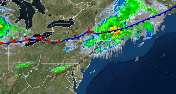
A cold front will drop through the region today with scattered to broken clouds and isolated showers and thunderstorms. The strongest thunderstorms are likely to be found over northeastern Pennsylvania and northern New Jersey which may feature intense downpours, frequent lightning, and wind gusts over 60 mph. Otherwise, most locations will remain dry. Winds will be from the west at 5 to 10 mph. Temperatures will rise into the mid-70s to
lower 80s over the interior, lower to mid-80s along the coast, and mid to upper 80s in the Delaware River Valley for highs.
TONIGHT
The cold front will stall over the region with scattered to broken cloud cover and isolated showers. Winds will veer to the northeast at 5 to 15 mph. Temperatures will fall into the mid to upper 60s for lows.
TOMORROW
The frontal boundary will lift north with scattered to broken clouds and isolated showers. Winds will veer to the southeast at 5 to 15 mph. Temperatures will rise into the upper 70s to mid-80s along the coast, lower to mid-80s over the interior, and mid-80s to lower 90s in the Delaware River Valley for highs.
WEDNESDAY
Another cold front will approach from the west with widely scattered to scattered showers and thunderstorms. The thunderstorms will be capable of heavy downpours, frequent lightning, and wind gusts over 40 mph. Winds will be from the south at 5 to 15 mph. Temperatures will range from the upper 60s to lower 70s for lows and upper 70s to mid-80s along the coast, lower to mid-80s over the interior, and upper 80s to lower 90s in the Delaware River
Valley for highs.
THURSDAY THROUGH MONDAY
The frontal boundary will stall and waver over the region with localized fog and low clouds in the morning and scattered cloud cover with isolated to widely scattered showers and thunderstorms in the afternoon. Temperatures on Thursday will range from the mid to upper 60s over the interior and upper 60s to lower 70s along the coast for lows and mid to upper 70s over the interior, upper 70s to lower 80s along the coast, and lower to mid-80s in the Delaware
River Valley for highs. Temperatures Friday through Monday will range from the mid to upper 60s over the interior and upper 60s to lower 70s along the coast for lows and upper 70s to lower 80s over the interior, upper 70s to mid-80s along the coast, and mid to upper 80s in the Delaware River Valley for highs.