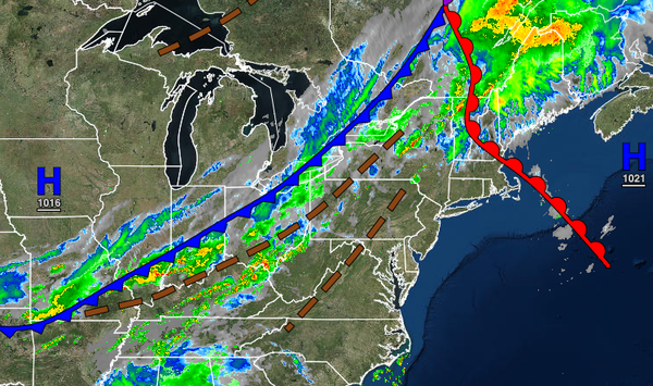
A cold front will set up a wet end to the week with scattered showers and thunderstorms. An unsettled weather pattern will be in place through next week with a maritime air mass.
TODAY
A cold front will approach with morning fog and low clouds giving with to scattered clouds and a few isolated showers. Winds will be from the south at 5 to 15 mph. Temperatures will rise into the upper 70s to lower 80s along the coast, lower to mid-80s over the interior, and mid to upper 80s in the Delaware River Valley for highs.
TONIGHT
The cold front will move through the region with scattered showers and thunderstorms. The thunderstorms will be capable of intense downpours, frequent lightning, small hail, and wind gusts over 40 mph. A few isolated severe thunderstorms with wind gusts over 60 mph will be possible. Winds will veer from the south to the west at 5 to 15 mph. Temperatures will fall into the lower to mid-60s over the interior and mid to upper 60s along the
coast for lows.
TOMORROW
The cold front will stall over the region with scattered to broken cloud cover and scattered showers. Winds will back to the southeast at 5 to 15 mph. Temperatures will rise into the mid-70s to lower 80s for highs.
TOMORROW NIGHT THROUGH FRIDAY
The cold front will remain stalled over the region with scattered to broken cloud cover with scattered showers capable of brief heavy downpours at times. Winds will be from the east at 5 to 15 mph. Temperatures on Friday will range from the upper 60s to lower 70s for lows and mid-70s to lower 80s for highs.
SATURDAY THROUGH WEDNESDAY
A stationary front will linger over the region while a high-pressure system over the Gulf of Maine will attempt to build south producing scattered cloud cover with isolated showers a threat each afternoon. Temperatures through Sunday will range from the lower to mid-60s over the interior and mid to upper 60s along the coast for lows and lower to mid-70s over the interior, upper 70s to lower 80s along the coast, and lower to mid-80s in the Delaware River
Valley for highs. Temperatures on Monday through Wednesday will range from the lower to mid-50s over the interior and lower to mid-60s along the coast for lows and mid to upper 70s over the interior and along the coast and upper 70s to lower 80s in the Delaware River Valley for highs.