Tranquil conditions today will give way to an increasing threat for showers tonight and a powerful cold front by Thursday night with heavy rainfall and embedded thunderstorms.
TODAY
High pressure will slowly exit the region today with clear skies to scattered cloud cover. Winds will be from the southeast at 5 to 15 mph. Temperatures will rise into the upper 60s to lower 70s over the interior, lower to mid-70s along the coast, and mid-70s to lower 80s in the Delaware River Valley for highs.
TONIGHT
Clouds will continue to increase with isolated showers rotating into the region from the Atlantic Ocean and from the Tennessee River Valley. Winds will be from the southeast at 5 to 15 mph. Temperatures will fall into the lower to mid-60s over the interior and upper 60s to lower 70s along the coast for lows.
TOMORROW
The cold front with a series of pre-frontal troughs will slowly approach the region with increasing cloud cover and isolated to widely scattered showers capable of brief heavy downpours. Winds will be from the southeast at 5 to 15 mph. Temperatures will rise into the lower to mid-70s over the interior, mid to upper 70s along the coast, and upper 70s to lower 80s in the Delaware River Valley for highs.
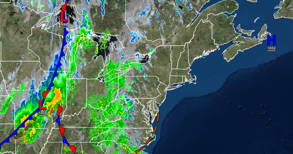
THURSDAY THROUGH FRIDAY
The cold front will slowly move through the region with waves of showers and embedded thunderstorms through Friday afternoon. The thunderstorms will be capable of heavy downpours and strong wind gusts over 40 mph. The heaviest rainfall over much of the region is expected Thursday evening through early Friday morning. Broken cloud cover and widely scattered to scattered showers are expected to linger on Friday afternoon and evening. Winds
will veer from the southeast at 10 to 20 mph to the northwest at 5 to 15 mph. Temperatures on Thursday will range from the mid-60s to lower 70s for lows and upper 60s to lower 70s over the interior and mid to upper 70s along the coast for highs. Temperatures on Friday will range from the lower to mid-50s over the interior, upper 50s to lower 60s in the Delaware River Valley, and lower to mid-60s along the coast for lows and mid-60s to lower 70s for highs.
SATURDAY
The cold front will linger over the coastal waters with scattered to broken cloud cover and isolated to widely scattered showers with a bulk of the showers along the coast. Temperatures will range from the lower to mid-50s over the interior and upper 50s to mid-60s along the coast for lows and lower to mid-70s for highs.
SUNDAY
Another cold front will follow with scattered clouds and isolated showers. Temperatures will range from the lower to mid-50s over the interior and upper 50s along the coast for lows and lower to mid-60s over the interior and upper 60s to lower 70s along the coast for highs.
MONDAY AND TUESDAY
High pressure will be in control with clear skies to scattered cloud cover. Temperatures on Monday will range from the mid to upper 40s over the interior and lower to mid-50s along the coast for lows and lower to mid-60s over the interior and upper 60s to lower 70s along the coast for highs. Temperatures on Tuesday will range from the upper 40s to lower 50s over the interior and lower to mid-50s along the coast for lows and upper 60s to lower 70s over
the interior, lower to mid-70s along the coast, and mid to upper 70s in the Delaware River Valley for highs.