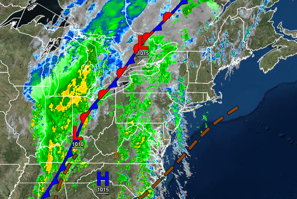
As a cold front slowly approaches the region through Friday, waves of showers and some thunderstorms will bring the threat of flash flooding, especially for eastern Pennsylvania and northwestern New Jersey.
TODAY
A prefrontal trough will produce broken to overcast skies with isolated showers. Winds will be from the southeast at 5 to 15 mph. Temperatures will rise into the mid to upper 70s over the interior and along the coast and lower to mid-80s in the Delaware River Valley for highs.
TONIGHT
The cold front will inch closer to the region with isolated to widely scattered showers increasing in coverage towards the morning hours. Winds will be from the southeast at 5 to 15 mph. Temperatures will fall into the upper 60s to lower 70s for lows.
TOMORROW
The cold front will start to move through eastern Pennsylvania and western New Jersey with waves of showers and thunderstorms while widely scattered showers can be expected further to the east. The heavy rainfall may produce flash flooding threats for eastern Pennsylvania and western New Jersey in the afternoon and evening hours. Winds will be from the southeast at 10 to 20 mph with gusts over 25 mph at times. Temperatures will rise into the mid
to upper 70s for highs.
TOMORROW NIGHT
The cold front will continue to press to the east with a wall of moderate to heavy rain with embedded thunderstorms pressing towards the coast. The intensity of the rainfall is expected to decline, but localized urban flooding remains a threat. Winds will veer from the southeast at 10 to 20 mph to the west at 5 to 15 mph. Temperatures will fall into the lower to mid-50s over the northern interior, upper 50s to mid-60s in the Delaware and Hudson
River Valleys, and upper 60s to lower 70s along the coast through Connecticut for lows.
FRIDAY
The cold front will stall over the coastal waters with heavy rainfall breaking up into scattered showers in the morning hours and widely scattered showers in the afternoon hours. Winds will be from the west at 5 to 15 mph. Temperatures will rise into the mid to upper 60s over the Poconos and Catskills and lower to mid-70s elsewhere for highs.
Rainfall amounts for this cold front passage are expected to range from 1.5" to 3.0" for eastern Pennsylvania, western New Jersey, and the Catskills while 0.50" to 1.50" of rain is expected for eastern New Jersey, the Hudson River Valley, the New York City metro, Long Island, and all of Connecticut.
SATURDAY
The cold front will remain stalled over the coastal waters with scattered to broken cloud cover and isolated to widely scattered showers. Temperatures will range from the upper 40s to lower 50s over the interior, lower to mid-50s in the suburbs, and upper 50s to lower 60s along the coast for lows and upper 60s to lower 70s over the interior and lower to mid-70s along the coast for highs.
SUNDAY
A cold front will move through with scattered clouds and isolated showers. Temperatures will range from the upper 40s to lower 50s along the coast, mid to upper 50s in the suburbs, and upper 50s to lower 60s along the coast for lows and mid to upper 60s over the interior and lower to mid-70s along the coast for highs.
MONDAY
High pressure will produce clear skies to scattered cloud cover. Temperatures will range from the mid to upper 50s over the interior and upper 50s to mid-60s along the coast for lows and lower to mid-70s over the interior, mid to upper 70s along the coast, and upper 70s to lower 80s in the Delaware River Valley for highs.
TUESDAY AND WEDNESDAY
A series of cold fronts will move through the region with isolated to widely scattered showers. Temperatures on Tuesday will range from the mid-50s to lower 60s for lows and mid-60s to lower 70s over the interior, lower to mid-70s along the coast, and mid to upper 70s in the Delaware River Valley for highs. Temperatures on Wednesday will range from the upper 40s to mid-50s over the interior and upper 50s to lower 60s along the coast for lows and lower
to mid-6os over the interior and upper 60s to lower 70s along the coast for highs.