A cold front will slowly approach the region with a wall of heavy rain and embedded thunderstorms pressing east through tomorrow morning. A cooler and unsettled weather pattern will remain in place through next week.
TODAY
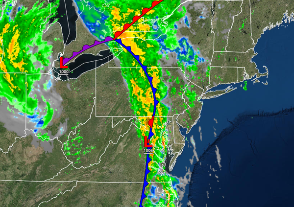
The cold front will slowly push to the east producing widely scattered showers throughout much of the region while heavy rain and thunderstorms push into eastern Pennsylvania by this afternoon. The thunderstorms will be capable of heavy downpours, frequent lightning, wind gusts over 40 mph, and isolated tornadoes. Winds will be from the southeast at 10 to 20 mph with gusts over 25 mph at times. Temperatures will rise into the lower to mid-70s
over the interior and upper 70s to lower 80s along the coast for highs.
TONIGHT
The cold front will continue to press east towards the coastal waters with waves of showers and thunderstorms reach the New Jersey coast, New York City metropolitan area, and Hudson River Valley by this evening and over Connecticut and Long Island by tomorrow morning. The thunderstorms will be capable of frequent lightning, intense downpours, and wind gusts over 40 mph. Winds will veer from the southeast to the west at 5 to 15 mph. Temperatures
will fall into the upper 40s to mid-50s in the Poconos and Catskills and mid-50s to lower 60s along the coast for lows.
TOMORROW
The cold front will stall over the coastal waters with widespread rainfall along the coast tapering off to isolated to widely scattered showers by the afternoon and evening hours. Winds will be from the west at 5 to 15 mph. Temperatures will rise into the lower to mid-60s over the interior, mid to upper 60s along the coast, and upper 60s to lower 70s in the Delaware River Valley for highs.
SATURDAY
The cold front will linger over the coastal waters with scattered to broken cloud cover and isolated showers. Winds will be from the west at 5 to 15 mph. Temperatures will range from the lower to mid-50s over the interior and mid to upper 50s along the coast for lows and upper 60s to lower 70s over the interior lower to mid-70s along the coast for highs.
SUNDAY
A cold front will move through the region with scattered cloud cover, isolated showers, and breezy conditions. Temperatures will range from the lower to mid-50s over the interior and upper 50s to lower 60s along the coast for lows and mid to upper 60s over the interior and lower to mid-70s along the coast for highs.
MONDAY
High pressure will produce clear skies to scattered cloud cover. Temperatures will range from the lower to mid-50s over the interior and upper 50s to lower 60s for lows and upper 60s to lower 70s over the interior, lower to mid-70s along the coast, and mid to upper 70s in the Delaware River Valley for highs.
TUESDAY THROUGH THURSDAY
A series of cold fronts will move through the region with scattered cloud cover and isolated showers. Temperatures on Tuesday will range from the mid to upper 50s over the interior and lower to mid-60s along the coast for lows and mid-60s to lower 70s over the interior, lower to mid-70s along the coast, and mid to upper 70s in the Delaware River Valley for highs. Temperatures on Wednesday and Thursday will range from the mid to upper 40s over the
interior, lower to mid-50s in the suburbs, and upper 50s to lower 60s in urban areas and along the coast for lows and lower to mid-60s over the interior and upper 60s to lower 70s along the coast for highs.