A tranquil start to the week will give way to a strong cold front tomorrow and an unsettled, cool weather pattern the rest of the week.
TODAY
High pressure will produce scattered to broken cloud cover through this evening. Winds will back from the west to the southwest at 5 to 15 mph. Temperatures will rise into the lower to mid-70s over the interior, mid to upper 70s along the coast, and upper 70s to lower 80s in the Delaware River Valley and urban areas.
TONIGHT
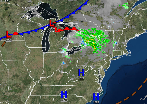
A cold front will approach with increasing cloud cover. Winds will be from the southwest at 5 to 15 mph. Temperatures will fall into the upper 50s to lower 60s over the interior and lower to mid-60s along the coast for lows.
TOMORROW
The cold front will move through the region with scattered showers and thunderstorms in the afternoon and evening hours. The thunderstorms will be capable of heavy downpours, frequent lightning, hail, and wind gusts over 60 mph. Winds will veer from the southwest to northwest at 5 to 15 mph with gusts over 20 mph at times. Temperatures will rise into the mid-60s to lower 70s over the interior, mid to upper 70s along the coast, and mid-70s to
lower 80s in the Delaware River Valley for highs.
WEDNESDAY
A weak trough will pass through the region with scattered clouds and an isolated shower possible in the afternoon hours. Winds will veer to the north at 5 to 15 mph. Temperatures will range from the lower to mid-40s over the interior, upper 40s to lower 50s in the suburbs, and lower to mid-50s along the coast and in urban areas for lows and upper 50s to lower 60s over the interior, mid to upper 60s along the coast, and mid-60s to lower 70s in the
Delaware River Valley for highs.
THURSDAY THROUGH MONDAY
A series of weak cold fronts and troughs of low pressure will rotate from the St. Lawrence River Valley to the coastal waters through the forecast period with scattered clouds and a few isolated showers. Temperatures on Thursday will range from the mid to upper 40s over the interior and lower to mid-50s along the coast for lows and mid-50s to lower 60s over the interior, lower to mid-60s along the coast, and mid to upper 60s in the Delaware River Valley for
highs. Temperatures on Friday will range from the upper 30s to mid-40s over the interior and upper 40s to mid-50s along the coast for lows and upper 50s to lower 60s over the interior and mid to upper 60s along the coast for highs. Temperatures on Saturday will range from the mid-40s to lower 50s for lows and mid-60s to lower 70s for highs. Temperatures on Sunday will range from the upper 40s to mid-50s for lows and lower to mid-70s over the interior and upper 70s to lower 80s
along the coast for highs. Temperatures on Monday will range from the lower to mid-50s over the interior and mid-50s to lower 60s along the coast for lows and mid-60s to lower 70s over the interior, lower to mid-70s along the coast, and mid-70s to lower 80s in the Delaware River Valley for highs.