A strong cold front will bring the threat for severe thunderstorms today followed by a cool, unsettled weather pattern through next weekend. A threat for heavy rainfall is developing for next week.
TODAY
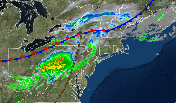
A strong cold front will move through the region with scattered showers and thunderstorms from noon through 8 PM this evening. The strongest thunderstorms are likely over the Philadelphia metropolitan area and central/southern New Jersey with intense downpours, frequent lightning, hail, and wind gusts over 60 mph, however, thunderstorms will remain a threat for the entire region as well. Winds will be from the southwest at 5 to 15 mph.
Temperatures will rise into the mid-60s to lower 70s in the Poconos and Catskills and mid-70s to lower 80s for the rest of the region for highs.
TONIGHT
The showers and thunderstorms will exit followed by clearing skies towards tomorrow morning. Winds will veer to the northwest at 5 to 15 mph. Temperatures will fall into the mid-40s to lower 50s over the interior and mid to upper 50s along the coast for lows.
TOMORROW THROUGH THURSDAY
A series of weak troughs will pass through the region with scattered clouds and a few isolated showers. Winds will be from the northwest at 5 to 15 mph. Temperatures tomorrow will rise into the lower to mid-60s over the interior and upper 60s to lower 70s along the coast for highs. Temperatures on Thursday will range from the upper 40s to lower 50s over the interior and lower to mid-50s along the coast for lows and upper 50s to lower 60s over the
interior and mid to upper 60s along the coast for highs.
FRIDAY THROUGH SUNDAY
A series of cold fronts and troughs will pass through the region with scattered clouds and isolated showers. Temperatures on Friday will range from the lower to mid-40s over the interior and upper 40s to lower 50s along the coast for lows and lower to mid-60s over the interior and mid-60s to lower 70s along the coast for highs. Temperatures on Saturday will range from the mid to upper 40s and upper 40s to mid-50s along the coast for lows and upper 60s
to mid-70s for highs. Temperatures on Sunday will range from the mid to upper 50s for lows and mid-60s to lower 70s over the interior, lower to mid-70s on the coast, and mid-70s to lower 80s in the Delaware River Valley for highs.
MONDAY AND TUESDAY
A cold front will stall over the region with waves of low pressure will producing waves of showers and rainfall, heavy at times. Temperatures on Monday will range from the upper 50s to mid-60s for lows and mid-60s to lower 70s over the interior, lower to mid-70s along the coast, and mid to upper 70s in the Delaware River Valley for highs. Temperatures on Tuesday will range from the mid to upper 50s over the interior and lower to mid-60s along the coast
and upper 50s to lower 60s over the interior and lower to mid-60s along the coast for highs.