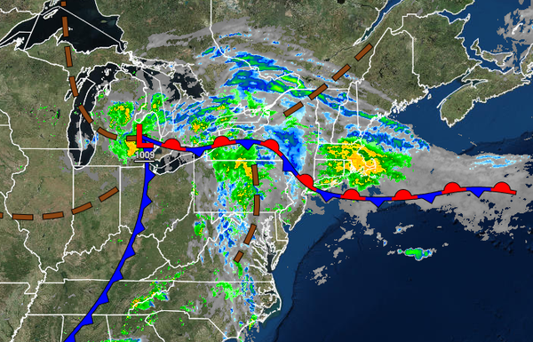
A stationary boundary and a cold front approach from the west will support periods of showers today. A stalled front will produce a threat for showers through this week.
TODAY
A stationary boundary will slowly sink to the south producing waves of showers over the northern interior and New York City metropolitan area and widely scattered showers over the Philadelphia metropolitan area and southern New Jersey. The showers will be capable of heavy downpours at times. Winds will back from the southwest to northeast at 5 to 15 mph as the stationary front slowly sinks south. Temperatures will range from the lower to mid-70s
over the northern interior and New York City metropolitan area and upper 70s to lower 80s in the Philadelphia metropolitan area and southern New Jersey.
TONIGHT
The cold front will pass through the region with widely scattered to scattered showers. The showers will be capable of heavy downpours. Winds will continue to back from the south to northeast at 5 to 15 mph. Temperatures will fall into the upper 50s to lower 60s over the interior and lower to mid-60s along the coast for lows.
TOMORROW THROUGH WEDNESDAY
A stationary front over the coastal waters will produce scattered to broken cloud cover with isolated to widely scattered showers. The showers will be capable of brief heavy downpours at times. Winds will be from the northeast at 5 to 15mph. Temperatures tomorrow will rise into the upper 60s to lower 70s for highs. Temperatures on Wednesday will range from the upper 50s to lower 60s for lows and upper 60s to lower 70s over the interior and
New York City metropolitan area and mid to upper 70s in the Philadelphia metropolitan area and southern New Jersey for highs.
THURSDAY THROUGH SATURDAY
The stationary front will remain over the coastal waters with scattered to broken clouds and isolated to widely scattered showers. Temperatures through the period will range from the mid to upper 50s over the interior and upper 50s to lower 60s along the coast for lows and mid-60s to lower 70s over the interior and New York City metropolitan area and mid to upper 70s in the Philadelphia metropolitan area and southern New Jersey for highs.
SUNDAY
An area of low pressure will produce periods of rain, heavy at times. Temperatures will range from the mid to upper 50s over the interior and lower to mid-60s along the coast for lows and lower to mid-60s over the interior and upper 60s to lower 70s along the coast for highs.
MONDAY
A stationary boundary will remain over the coastal waters with scattered to broken clouds and isolated to widely scattered showers. Temperatures will range from the upper 50s to lower 60s over the interior and mid to upper 60s along the coast for lows and lower to mid-70s for highs.