A powerful cold front will move through the region this afternoon and evening with heavy rainfall and severe thunderstorms. A cool, breezy weather pattern returns by tomorrow morning.
TODAY
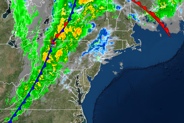
A strong cold front will move through with periods of rain and embedded thunderstorms in the afternoon and evening hours. The thunderstorms will be capable of intense downpours, occasional to frequent lightning, wind gusts over 40 mph, and an isolated tornado. The cold front is expected to impact eastern Pennsylvania, the Catskills, and Delaware River Valley from 2 PM to 8 PM, the New Jersey coast, New York City metropolitan area, and the Hudson River
Valley from 5 PM to 11 PM, and Long Island and Connecticut from 7 PM through midnight. Winds will veer from the south to the west at 10 to 20 mph with higher gusts. Temperatures will rise into the upper 60s to lower 70s over the interior, lower to mid-70s along the coast, and mid-70s to lower 80s in the Delaware River Valley for highs.
TONIGHT THROUGH TOMORROW
The cold front will depart in the morning hours with scattered clouds and an isolated shower a threat through the afternoon. Winds will be from the west at 10 to 20 mph with gusts up to 30 mph at times. Temperatures will range from the lower to mid-40s over the interior, upper 40s to lower 50s in the suburbs, and lower to mid-50s in urban areas and along the coast for lows and mid to upper 50s over the interior and lower to mid-60s along the coast for
highs.
MONDAY
High pressure will build into the region with clear skies to scattered clouds. Winds will be from the west at 10 to 20 mph. Temperatures on Monday will range from the lower to mid-40s over the interior and upper 40s to lower 50s along the coast for lows and mid to upper 50s over the interior and lower to mid-60s along the coast for highs.
TUESDAY THROUGH THURSDAY
High pressure will be in control through the forecast period with clear skies to scattered cloud cover. Temperatures on Tuesday and Wednesday will range from the upper 30s to lower 40s over the interior and mid to upper 40s along the coast for lows and lower to mid-60s over the interior, mid to upper 60s along the coast, and upper 60s to lower 70s in the Delaware River Valley for highs. Temperatures on Thursday will range from the lower to
mid-50s over the interior and upper 50s to lower 60s along the coast for lows and mid-50s to lower 60s over the interior and mid to upper 60s along the coast for highs.
FRIDAY
A weak cold front will move through with a few isolated showers and scattered clouds. Temperatures will range from the lower to mid-50s over the interior, mid to upper 50s in the suburbs, and upper 50s to lower 60s along the immediate coast for lows and lower to mid-60s over the interior and upper 60s to lower 70s along the coast for highs.
SATURDAY
A wave of low pressure will develop along the departing cold front which will produce periods of showers throughout the region, especially along the coast. Temperatures will range from the upper 40s to the lower 50s over the interior and lower to mid-50s along the coast for lows and mid to upper 50s over the interior and lower to mid-60s along the coast for highs.