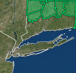
The National Weather Service in Norton has issued a

* Flood Watch for portions of northern Connecticut, Massachusetts
  and Rhode Island, including the following areas, in northern
  Connecticut, Hartford CT, Tolland CT and Windham CT. In
  Massachusetts, Central Middlesex MA, Eastern Essex MA, Eastern
  Franklin MA, Eastern Hampden MA, Eastern Hampshire MA, Eastern
  Norfolk MA, Eastern Plymouth MA, Northern Bristol MA, Northern
  Middlesex MA, Northern Worcester MA, Southeast Middlesex MA,
  Southern Bristol MA, Southern Plymouth MA, Southern Worcester MA,
  Suffolk MA, Western Essex MA, Western Hampden MA, Western
  Hampshire MA, Western Norfolk MA and Western Plymouth MA. In Rhode
  Island, Block Island RI, Bristol RI, Eastern Kent RI, Newport RI,
  Northwest Providence RI, Southeast Providence RI, Washington RI
  and Western Kent RI.

* From late tonight through Wednesday evening.

* A rapidly developing low pressure system will likely produce heavy
  rainfall across the region. Rainfall totals of 3 to 5 inches with
  locally higher amounts possible. Rainfall rates may exceed one
  inch per hour at times.

* Heavy rainfall may cause flooding of roads and ponding of water in
  low lying areas. The Tuesday evening commute may be particularly
  impacted.

PRECAUTIONARY/PREPAREDNESS ACTIONS...

You should monitor later forecasts and be alert for possible Flood
Warnings. Those living in areas prone to flooding should be prepared
to take action should flooding develop.