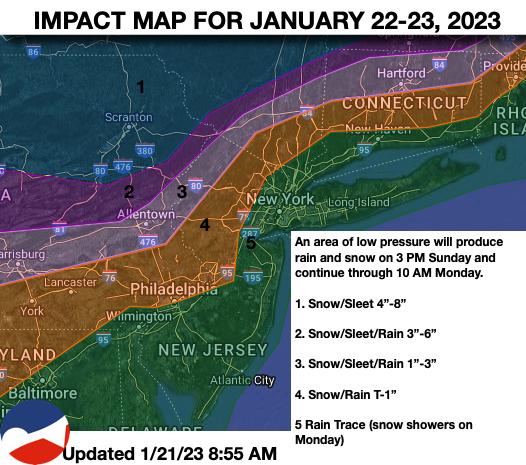
A winter storm is on the way with rain, ice, and snow on the way for tomorrow afternoon. Another winter storm will bring more rain, ice, and snow on the way by Wednesday.
TODAY
High pressure will depart with increasing cloud cover. Winds
will be from the northwest at 5 to 15 mph. Temperatures will rise into the lower to mid-30s over the interior and upper 30s to lower 40s along the coast for highs.
TONIGHT
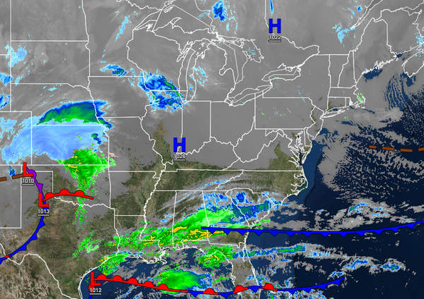
An area of low pressure will approach with increasing clouds. Winds will back from the northwest to the southeast at 5 to 15 mph. Temperatures will fall into the mid to upper
20s for lows.
TOMORROW
Clouds will increase through the morning. Periods of rain will develop along the coast while a mix of snow, sleet, and rain will develop along and northwest of the I-95 corridor. In the Poconos, Catskills, northwestern New Jersey, Hudson River Valley, and northern Connecticut; a mix of snow and sleet is expected in the afternoon and
evening hours. Winds will back from the southeast to the northeast at 5 to 15 mph. Temperatures will rise into the upper 30s to lower 40s over the interior and lower to mid-40s along the coast for highs.
TOMORROW NIGHT
An area of low pressure will produce periods of snow and sleet in the Poconos and Catskills, a mix of snow, sleet, and rain for locations
north and west of the I-95 corridor that will mix over to rain, and rain on the I-95 corridor and along the coast. Winds will back from the northeast to the northwest at 5 to 15 mph. Temperatures will fall into the lower to mid-30s over the interior and mid to upper 30s along the coast for lows.
MONDAY
The area of low pressure will exit the region with snow
over the interior and a wintry mix of snow, sleet, and rain along the coast ending as snow showers by the afternoon. Winds will be from the northwest at 5 to 15 mph. Temperatures will rise into the lower to mid-30s over the interior and upper 30s to lower 40s along the coast for highs.