A winter storm is approaching from the west today with increasing clouds and a wintry mix mess tonight. Another winter storm is brewing for the end of the week.
TODAY
A warm front and a wave of low pressure will approach with increasing clouds
through the day followed by snow, sleet, and rain developing towards evening. Winds will be from the northeast at 10 to 20 mph. Temperatures will rise into the upper 30s to lower 40s over the interior and lower to mid-40s along the coast for highs.
TONIGHT
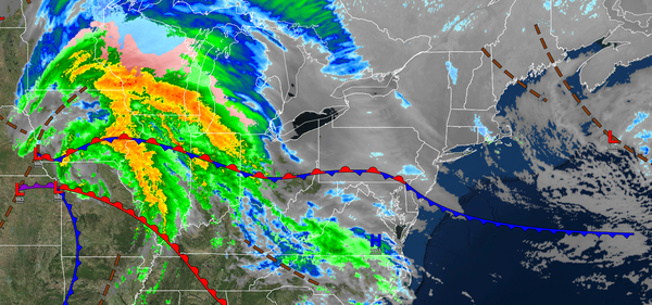
The area of low pressure will intensify over the coastal waters with periods of rain over southeastern
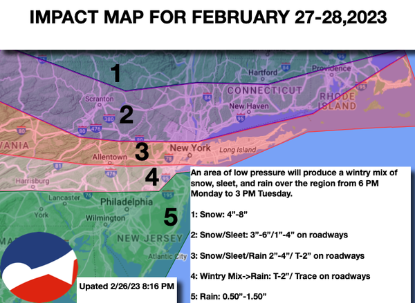
Pennsylvania, central New Jersey, and southern New Jersey, a wintry mix of snow, sleet, and rain over northeastern Pennsylvania, northern New Jersey, the New York City metropolitan area, and Long Island, and snow and sleet in the Catskills, Hudson River Valley, and Connecticut. Please see the impact map below. Winds will back to the northwest at 10 to 20 mph. Temperatures will fall into the upper 20s to lower 30s over the interior and lower to mid-30s along the coast for
lows. Please see the impact map below the discussion for more details.
TOMORROW
An area of low pressure will exit with periods of snow and sleet over the interior; snow, sleet, and rain in the New York City metropolitan area, and periods of rain in the Philadelphia metropolitan area and southern New Jersey. Winds will be from the north at 5 to 15 mph.
Temperatures will rise into the mid to upper 30s over the interior and upper 30s to lower 40s along the coast for highs.
TOMORROW NIGHT
High pressure will build into the region with clearing skies. Winds will be from the northeast at 5 to 15 mph. Temperatures will fall into the lower to mid-20s over the interior and upper 20s to lower 30s along the coast for
lows.
WEDNESDAY
High pressure will pass through the region with scattered clouds. Winds will be from the northeast at 5 to 15 mph. Temperatures will rise into the lower to mid-40s over the interior, mid to upper 40s in the New York City metropolitan area, and upper 40s to lower 50s in the Philadelphia metropolitan area for
highs.
THURSDAY
A cold front will approach the region with scattered showers. Winds will be from the northwest at 5 to 15 mph. Temperatures will range from the mid to upper 30s for lows and lower to mid-50s over the interior, mid to upper 50s in the New York City metropolitan area, and lower to mid-60s in the Philadelphia metropolitan area for
highs.
FRIDAY
An area of low pressure will produce a wintry mix over the interior and a wintry mix to rain along the coast. Temperatures will range from the mid to upper 20s over the interior and lower to mid-30s along the coast for lows and upper 20s to mid-30s over the interior and upper 30s to mid-40s along the coast for highs.
SATURDAY
A series of troughs will follow with scattered snow showers. Temperatures will range from the upper 20s to mid-30s for lows and upper 30s to lower 40s over the interior and mid to upper 40s along the coast for highs.
SUNDAY
High pressure will produce scattered
clouds. Temperatures will range from the lower to mid-30s over the interior and upper 30s to lower 40s over the interior and mid to upper 40s along the coast for highs.
MONDAY
High pressure will produce scattered clouds. Temperatures will range from the mid-10s to lower 20s over the interior and mid-20s to lower 30s for lows and lower to mid-40s over the
interior and upper 40s to lower 50s along the coast for highs.