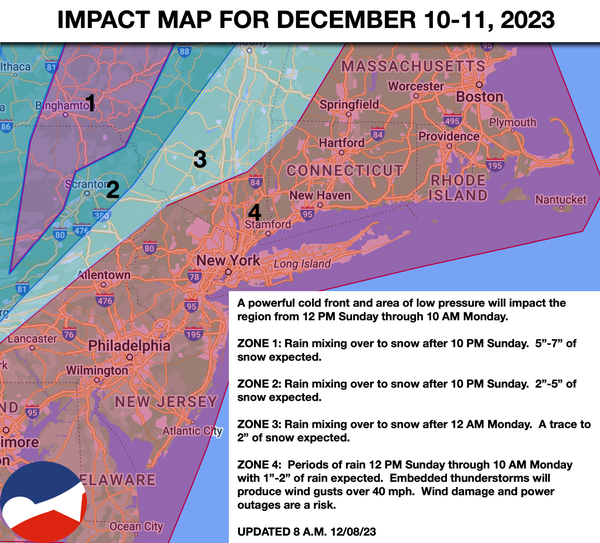
Tranquil conditions will be in place today and tomorrow. A powerful cold front and a wave of low pressure will bring heavy rain, strong winds, and snow on Sunday into Monday morning.
TODAY
High pressure will pass over the
region with scattered clouds. Winds will be from the south at 5 to 10 mph. Temperatures will rise into the mid to upper 40s over the interior and upper 40s to lower 50s along the coast for highs.
TONIGHT
High pressure will produce clear skies and scattered clouds. Winds will be from the south at 5 to 15 mph.
Temperatures will fall into the lower to mid-30s over the interior and mid to upper 30s along the coast for lows.
TOMORROW
High pressure will exit the region with increasing clouds. Winds will be from the south at 5 to 10 mph. Temperatures will rise into the lower to mid-50s for highs.
TOMORROW NIGHT
As a cold front approaches, clouds will increase with winds from the south at 5 to 15 mph. Temperatures will fall into the lower to mid-30s away from the coast and mid to upper 30s on the immediate coast for lows.
SUNDAY
An area of low pressure and a strong cold front will approach with increasing clouds followed by periods of rain in the evening. Winds will be from the south at 10 to 20 mph with gusts over 40 mph, with power outages and wind damage. Temperatures will rise into the upper 50s to lower 60s over the interior and lower to mid-60s along the coast for highs in the evening.
MONDAY
A powerful cold front will exit in the morning hours with periods of rain and embedded thunderstorms with very windy conditions. The rain may mix with snow before ending in the Poconos and Catskills with some accumulation. Will will veer from the south to the northwest at 10 to 20 mph with gusts between 25 to 50 mph. Power outages and wind damage will be
a threat in the early morning. Temperatures will fall from the 50s and 60s early in the morning into the 40s, 30s, and 20s by the afternoon.
TUESDAY
High pressure will produce scattered clouds. Temperatures will range from the lower to mid-20s over the interior and upper 20s to lower 30s along the coast for lows and lower to
mid-30s over the interior and upper 30s to lower 40s along the coast for highs.
WEDNESDAY
High pressure will produce scattered clouds. Temperatures will range from the lower to mid-2s over the interior and upper 20s to lower 30s along the coast for lows and upper 30s to lower 40s over the interior and mid-40s to lower 50s along the
coast for highs.
THURSDAY
High pressure will produce scattered clouds. Temperatures will range from the upper 10s to lower 20s over the interior and mid to upper 20s along the coast for lows and mid to upper 30s over the interior and lower to mid-40s along the coast for highs.
FRIDAY
High pressure will produce scattered clouds. Temperatures will range from the upper 10s to lower 20s over the interior and mid to upper 20s along the coast for lows and mid-30s to lower 40s over the interior and mid-40s to lower 50s along the coast for highs.