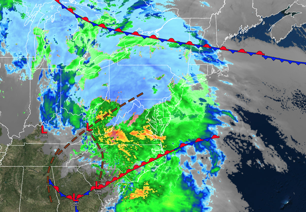
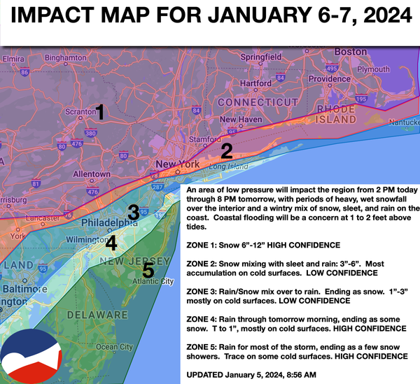
A winter storm is approaching the region, with areas of rain and snow already developing. A wintry mix of impacts can be expected through tomorrow. Another storm will approach on Tuesday night with heavy rainfall, flash flooding, and the potential for wind damage and power outages.
12 PM
THROUGH 5 PM TODAY
Overcast skies with developing rainfall over southern New Jersey and snowfall for the rest of the region can be expected. Winds will be from the east-northeast at 10 to 20 mph. Temperatures will rise into the lower to mid-30s over the interior and mid to upper 30s along the coast for highs.
5 PM TODAY THROUGH
MIDNIGHT TONIGHT
Waves of rainfall can be expected throughout southern New Jersey and the central New Jersey coast. Meanwhile, a winter mix of snow, sleet, and rain can be expected along the I-95 corridor. Periods of heavy, wet snow will continue north and northwest of the I-95 corridor. Winds will back to the north-northeast at 10 to 20 mph. Temperatures will hold in the lower to mid-30s over
the interior and mid to upper 30s along the coast.
12 AM THROUGH 6 AM TOMORROW
Waves of rainfall can be expected throughout southern New Jersey and the central New Jersey coast. Meanwhile, a winter mix of snow, sleet, and rain will mix to snow along the I-95 corridor. Periods of heavy, wet snow will continue north and northwest
of the I-95 corridor. Winds will back to the north at 10 to 20 mph. Temperatures will fall into the upper 20s to lower 30s over the interior and mid to upper 30s along the coast.
6 AM THROUGH 4 PM TOMORROW
Periods of heavy snow will continue over the interior while the wintry mix and rain will change over to snow along the coast.
Winds will back to the northwest at 10 to 20 mph. Temperatures will fall steadily through the 30s into the 20s.
4 PM THROUGH 8 PM TOMORROW
The snow will taper off to snow showers from west to east. Winds will be from the northwest at 10 to 20 mph. Temperatures will continue to fall through the
20s.