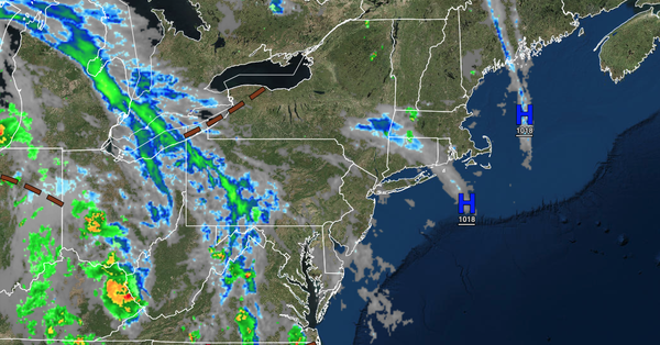
Exiting high pressure will support an increase in clouds tonight. Showers and thunderstorms will return by tomorrow evening.
TONIGHT
High pressure will exit with increasing clouds. Winds will veer to the east at 5
to 15 mph. Temperatures will fall into the lower to mid-60s for lows.
TOMORROW
A warm front will approach the region with increasing clouds and widely scattered showers. Widespread showers and thunderstorms are expected in the evening. Winds will veer to the southeast at 5 to 15 mph. Temperatures will rise into the
mid to upper 70s on Long Island and lower to mid-80s elsewhere for highs.
TOMORROW NIGHT
A warm front will produce periods of showers and thunderstorms. The thunderstorms will be capable of heavy downpours, occasional lightning, and wind gusts over 40 mph. Winds will veer to the southwest at 5 to 15 mph. Temperatures will
fall into the mid to upper 60s for lows.
THURSDAY
A warm front will lift through the region with scattered showers and thunderstorms. Winds will veer to the west at 5 to 15 mph. Temperatures will rise into the mid to upper 70s along the coast and upper 70s to lower 80s elsewhere for highs.
FRIDAY
A trough will linger over the region with scattered clouds and isolated showers and thunderstorms. Winds will be from the west at 5 to 15 mph. Temperatures will range from the upper 50s to lower 60s over the interior and lower to mid-60s along the coast for lows and lower to mid-70s over the interior and upper 70s to lower 80s along the coast for
highs.
SATURDAY
A trough will linger over the region with scattered clouds and isolated showers and thunderstorms. Winds will be from the west at 5 to 15 mph. Temperatures will range from the lower to mid-50s over the interior and upper 50s to lower 60s along the coast for lows and upper 60s to lower 70s over the interior and
lower to mid-70s along the coast for highs.
SUNDAY
A trough will linger over the region with scattered clouds and isolated showers and thunderstorms. Temperatures will range from the upper 40s to lower 50s over the interior and mid to upper 50s along the coast for lows and upper 60s to lower 70s on Long Island, lower to mid-70s along
the coast, upper 70s to lower 80s in the Delaware River Valley, and mid to upper 70s over the interior for highs.
MONDAY
A trough will linger over the region with scattered clouds and isolated showers and thunderstorms. Temperatures will range from the lower to mid-50s over the interior and mid to upper 50s along the coast for lows and
lower to mid-70s over the interior and upper 70s to lower 80s along the coast for highs.
TUESDAY
A trough will linger over the region with scattered clouds and isolated showers and thunderstorms. Temperatures will range from the upper 50s to lower 60s over the interior and lower to mid-60s along the coast for lows and lower to mid-70s
for highs.
WEDNESDAY
High pressure will produce scattered clouds. Temperatures will range from the lower to mid-50s over the interior and upper 50s to lower 60s along the coast for lows and mid to upper 70s over the interior, upper 70s to lower 80s along the coast, and lower to mid-80s in the Delaware River Valley for
highs.